Traveller Worlds

TRAVELLER 5
Science fiction adventure, in the far future.
Saved Systems list:
Edit Star Details
Edit gas giant details.
Rendering ...
World Name:
Note well: the map will be redrawn using the seed above if you alter any UWP digit. You can change this setting to prevent this by going to View > Your Preferences. If you switch automatic redrawing off, the map may not match how you have changed the UWP (e.g. size or hydrographics may be wrong).
Orbit Details
Orbital Distance:
Adjust orbit with first up and down arrows; adjust the decimal place with the second:
Orbital Period:
World is Tidally Locked to its star
The world's rotational period is the same as its orbital period and cannot be changed. The Axial Tilt is zero and cannot be changed. One side is always facing towards the star and is permanently day, the other is permanently night. The 'day' and 'night' sides are set to the upper and lower temperature limits which is based on the atmosphere.
World is a satellite Tidally Locked to its planet
The world's rotational period is the same as its orbital period and cannot be changed. The Axial Tilt represents the inclination of its orbit around the planet relative to the planet's orbit around the star and so there can be seasonal influences. One side is always facing towards the planet, leading to long days and nights relative to the parent star. Note: The T5 rules specify that satellite orbits 'em' and closer will be locked to their planet. If a randomly generated satellite rotation or user entered result is greater than the orbital period, it will be reduced to the orbital period and regarded as tidally locked.
Port Details
Starport Class
Refined Hydrogen Fuel
Unrefined Hydrogen Fuel
Fissionable Radioactives
Anti-matter fuel slugs
Replacement Collector Canopies
Size Details
Size UWP value explanation:
Diameter (km):
Density Type:
Density (Earth=1):
Mass (Earth=1):
Gravity (G):
Rotational Period (Hours):
Jump Point (km):
Time to Jump Point at ...:
Belt Details
Predominant Size
Maximum Size
Belt Width (AU)
N-zone percentage
M-zone percentage
C-zone percentage
Atmosphere and Temperature details
Atmosphere UWP digit explanation
Atmospheric Pressure
Atmospheric Composition
Greenhouse Effect
Axial Tilt (degrees)
Base World Temperature
Average Daytime Temperature
Average Nighttime Temperature
Summer Increase
Winter Decrease
Upper Temperature Limit
Lower Temperature Limit
Hydrosphere Details
Hydrographic Percentage
Surface Liquid Composition
Native Life?
Seismic Stress
Natural Resources
Processed resources, manufactured resources, population details.
Population Digit from UWP
Population Multiplier
Total Population
Intelligent Life Status
Government Details
Government Digit from UWP
More generated detail about government
For more about this government detail, click HERE
Law Details
Law Level Digit from UWP
Law level explanation
Technology Details
Technology Level Digit from UWP
Historical Era
Environment
Communications
Developing Science
Latest Technology
Fastest Speeds
Personal Weapons
Heavy Weapons
Space Travel
Space Weapons
Space Defences
Starship sensors
World range sensors
Noble Codes
Noble Descriptions
Economic Extension
Infrastructure
Cultural Extension
Heterogeneity
Strangeness
-4 -3 -2 -1 0 1 2 3 4 5
Temperature Table
System generation preferences, map generation preferences, map colours.
Default Sector:
Error: sectors not loaded
Select a world:
Error: worlds not loaded
(Data imported directly from travellermap.com ).
Hex and Sector
UWP (in the format XNNNNNN-N)
Trade Codes and Remarks
0 1 2 3 4 5 6 7 8 9
Planetoid Belts
0 1 2 3 4 5 6
2 3 4 5 6 7 8 9 10 11 12
Stellar Data
Additional Trade codes
Frozen (Fr) Planet is further out than the Habitable Zone plus 2 orbits. All lands and oceans are frozen.
Tundra (Tu) Planet is somewhat earth-like but in the next orbit out from the Habitable Zone. Land and ocean near the ice caps is frozen.
Twilight Zone (Tz) Planet is tidally locked to its star with one face always pointing towards it and another facing away.
Farming (Fa) Planet is not a main world but is in the HZ and meets other criteria.
Mining (Mi) Planet is not a main world and the main world is Industrial.
Add world, gas giant or planetoid belt
Select which available orbit to add an object, and select the object type. The details will be randomly generated. You can then edit them.
API Documentation
You can encode a link for a particular star system by using a URL. For example:
http://travellerworlds.com/?name=Junidy&uwp=B434ABD-B
This example will put the world name 'Junidy' in the World Name field, the UWP 'B434ABD-B' in the UWP field, and then randomly generate all remaining details before generating a world map and the star system.
Note that when a system is generated, the main world map and details are generated and displayed; you can then navigate to each world via the Full Star System View and go to another world by pressing the "Details" button next to that world.
All world variables relevant to a world map can be used. Note that the URI needs to be encoded to ensure it works correctly. The following is a comprehensive list of variables used and how they are handled.
hex - the four-digit sector co-ordinate of the system (e.g. hex=3202 - Junidy is 3202 in the Spinward Marches). Default value: empty string.
sector - the name of the sector (e.g. sector=Spinward%20Marches). Default value: empty string.
name - the name of the world (e.g. name=Junidy). Default value: empty string.
system - the name of the system; Default value: the name of the world followed by the hex location and sector in parentheses, e.g. "Junidy (3202 Spinward Marches)". This is used by the map to make the location of the world meaningful when it is a non-main world.
uwp - the uwp in the format SSAHPGL-T where S is the port (letters A-H, X, Y) and the remaining digits are extended hexademical. Default value: randomly generated.
tc - relevant two-letter trade classification, Can be specified as many times as there are relevant Trade Classifications, e.g. "tc=In&tc=Hi". Default Value: generated TCs from UWP, whether the UWP is randomly generated or provided. Use this to specify TCs that cannot be derived from the UWP (e.g. Twilight Zone).
iX - the Importance rating of the world, e.g. iX=4. Default value: generated by UWP, bases and TC values using T5 rules.
eX - the Economic extension for the world including the parenthesis, e.g. eX=(D9E+4). Default value: randomly generated using T5 rules.
cX - the Cultural extension for the world including the brackets, e.g. cX=[5E86]. Default value: randomly generated using T5 rules.
pbg - the PBG 3-digits (Population Multiplier, Belts, Gas Giants). If no pbg parameter is specified, the script looks for the belts, gas_giants, and popMulti parameters and uses their defaults if they are not found.
popMulti - the Population Multiplier (first digit of the PBG), e.g. popMulti=2. Default value: randomly generated even chance 1 to 9.
belts - the number of Planetoid Belts (second digit of the PBG), e.g. belts=1. Default value: randomly generated using T5 rules.
gas_giants - the number of Gas Giants (third digit of the PBG), e.g. gas_giants=0. Default value: randomly generated using T5 rules.
worlds - the total number of other worlds in the system, including gas giants, belts, the main world and other planets. If this value is less than gas giants plus belts plus the main world, it will be raised to that value. Default value: randomly generated using T5 rules.
bases - a string containing all bases present, e.g. bases=NS or bases=W. Possible bases read are N, S, W, and D. Default value: test for bases randomly using Starport and T5 rules. Specify bases= to force bases to be nothing.
nobz - a string specifying all Nobles for this world, e.g. nobz=BcC. Default value: generated from TCs.
allegiance - a string specifying the allegiance of the system, e.g. allegiance=Im. Default value: blank.
seed - the seed used to randomly generate the map. Default value: the hex of the system concatenated to itself. If the hex is not specified, 'undefined' is used.
3 October 2023
New Host: TravellerWorlds has switched to travellerworlds.com instead of an obscure amateur URL. Ahhhh. Professional looking URL.
Bug fix: When a world's atmosphere is 9, atmospheric pressure was using the "very dense" table, which is reserved for extreme Venus-like cases. Was leading to odd results. Many thanks to a sharp-eyed user for pointing this out!
Bug fix: Importance was not reading correctly when passed in via GET data, e.g. from TravellerMap. Allowing reading of the Importance instead of only generating it allows for custom mods to standard Importance values.
11 June 2023
Layout Changes: Working on planet detail layout changes to make it more compact and pleasing to the eye. Paragraph explanations (apart from Government) changed to tables of information.
Bug Fix: Export to CSV was not working; fixed.
31 May 2023
Bug Fix: If 'allegiance' was not provided in the URL, then the world and system were prevented from generating by a fatal error. Now fixed.
Beast Armour: Beast Armour generation added to "View > Beasts (experimental)".
Bug Fix: Half-terrain from Twilight Zones appearing in key for that World Hex Map. Now fixed.
Bug Fix: Beasts of Size 4 did not have Strength modifier applied in Beasts (experimental).
Bug Fix: Locomotion of Beasts in Beasts (experimental) had combinations not intended (e.g. Flyphibians in Clear terrain).
Bug Fix: Download buttons for World, Terrain and Local hexes were not working. Fixed.
Bug Fix: Cropped Map image had incorrect file extension of "svg" instead of "png". Fixed.
Experimental Beasts: Beast tables generated through a modified rule set. Thus, "View > Beasts (demo)" is RAW, "View > Beast (experimental)" is modified rules.
18 April 2023
Beast Maker demo: For any world you can choose View > Beasts (demo) to generate beast tables for each of 11 terrain types. This feature will be improved in future to fully edit the beasts including all T5 details and save the data with the system.
8 April 2023
10 september 2022.
Bug Fix: Belts could not be placed by using "System Actions > Add a celestial object to the system" due to an error caused by the new Belt Details release. Now fixed.
24 July 2022
Bug Fix: The fix for the different results for seeds had knock-on errors that slipped through my testing, and affected nearly any world one would attempt to generate by navigating from TravellerMap. Now fixed.
17 July 2022
Bug Fix: This was a misconception on my part. The "number of worlds" statistic for a system indicates the total number of gas giants, belts, and other worlds in the system. I was getting it to generate other worlds ON TOP OF gas giants, belts and the main world. Systems will look smaller from now on.
Bug Fix: Saving and loading systems was changing the position of stars and messing with other objects as a consequence. This was due to the seed for the system not being read correctly.
Bug Fix: The system generation was giving a different result almost every time, whether data was coming in from Traveller Map, the user was entering their own data, or the user was regenerating with the "current seed". This error was due to me not being careful with when and where I initiated the RNG with the correct seed.
9 July 2022
Belt Details and map: Planetoid and Asteroid Belts now have details generated - their zones, and the total belt width, and the predominate and maximum sizes of objects in the belt. The Belt now has a map indicating the relative size of each zone. All belt details are fully editable and saveable with the system.
Twilight Zone alteration: Ice cap terrain is now removed from Twilight Zone worlds.
Habitable Zone reset: The Habitable Zone value for each star has now been refined to a decimal orbit (where each 0.1 is 10% of the distance from the inner orbit to the next orbit). If the Main World is to be placed in the precise Habitable Zone (i.e. not HZ+1 or HZ-1) then TravellerWorlds now places it in this new refined value. The new HZ value has been calculated by the distance that a planet with Greenhouse of +10% and Albedo of 0.3 would need to be from that star for an average temperature of 288 K / 15°C. Note that due to varying Albedo and Greenhouse effect this will not always be the exact temperature. This more exact placement is to help world builders obtain more Earth-like conditions more easily; many results quite frankly created extreme worlds even if they were Ag Ri Ga worlds.
4 July 2022
Bug Fix: Fixed an introduced bug stopping Local Hexes from completing correctly.
Bug Fix: When Cultural Extension and Economic Extension data was not passed to TravellerWorlds it would freeze.
Importance: Importance is now imported from data rather than only generated. It can also be edited by the user. Its default value is to generate the Importance rating using T5 rules, but it can be edited by the user (e.g. when establishing capitals).
Star Details: When editing star details, calculated values (luminosity, mass, diameter, jump point) are displayed and updated as you edit.
Gas Giant Details: Gas giant details can now be edited, and details such as mass and jump points are displayed and updated as you edit.
3 January 2022
Bug Fix: In the background, the map was generating a random map before loading the data because this was required for the setup before data was loaded. Set up and generation are now separate procedures.
Bug Fix: In map editing mode, certain hexes were incorrectly creating a World Hex Map when clicked. Now fixed.
27 December 2021
Map Editing: There is now a (very basic!) map editor. This is an EARLY version and is still buggy, but the basics work. Navigate to the world you wish to edit, and then choose Map Actions > Edit the Current Map. Then click on one of the types of terrain at the top. Clicking the hex will add the terrain. You can remove symbols (e.g. rural, cities, etc.) by clicking again. Base terrain (e.g. clear, oceans) cannot be removed but can be replace with other terrain.
Bug Fix: Atmospheres of types exotic, corrosive and insidious had a bug where the atmospheric pressure table was not saving correctly, leading to all sorts of loading and saving problems. Some of your older systems might still not be able to save or load correctly, many apologies.
23 December 2021
Background mapping change: new political border terrain added in anticipation of being able to edit maps. Users can edit the downloaded JSON of worlds to add these codes in. Users can also change the default colour for these borders.
22 December 2021
All UWP details explained: Each digit of the UWP for each world is now fully explained - the last to be added were law level and technology level.
Add objects: The user may now add objects to the system - stars, gas giants, planets and satellites
28 November 2021
Bug fix: When changing orbits of worlds, Trade Classifications and Remarks (in particular: Ho, Co, Tu and Tz) were not updating correctly. The drawback is only that 'custom' remarks such as Ownership codes (e.g. O:2355) will be removed if you change orbits.
Bug fix: Orbits of satellites could be changed and the change of the name would save, but the orbital distance, rotation period and locking status would not change. Now fixed - changing any satellite's orbit updates the orbital distance, orbital period, and recalculates whether the satellite is locked to its planet and if not randomly generates a rotation period.
Bug fix: When loading a system from a JSON file, TravellerWorlds was regenerating the map using the seed instead of loading the map data. In theory, a user can edit the JSON file directly and upload the file to show terrain the user has put in such as extra cities, a second starport or other features. At present, this editing can only be done by the user directly editing the JSON file using a text editor.
Bug fix: If you change a digit of a UWP, the map will now automatically be redrawn. In anticipation of users being able to edit their own maps, this can be turned off so that users can make minor adjustments if they have edited the map and prevent their work being overwritten.
25 November 2021
Bug fix: Map data was not saving and importing correctly when using expanded noble estates
Bug fix: When regenerating the whole system, the main world details were displaying incorrectly in the table showing symbols for each celestial object.
Edit Star Details: You may now edit the Spectral Class and Spectral Size of the star, and vary its luminosity, size and mass using a multiplier for the base values. At present, this still allows you to put in unrealistic values, so no warranties provided as to realism.
18 May 2021
Generate missing data: upload a CSV file of names and UWPs, and get back a CSV file with all T5 details generated.
16 May 2021
Bug Fix: Travel times to jump points were calculating incorrectly because I had forgotten to convert units properly. Thanks to BasicPassage on Citizens of the Imperium for bringing it to my attention!
15 May 2021
Map Data download: Terrain data for a world map (only) can be downloaded as a JSON file. I will be posting a help page to explain how the data works so you can use it in your own projects. In the background, when you save a system, the actual terrain data is saved and loaded, so you can generate maps until you get one you like before you save the system or download it as a JSON file. JSON files of the whole system now include generated maps. The ability to save the actual terrain data is a pre-requisite to being able to edit the data. Yes, you read that right. Watch this space, O Patient Users.
16 April 2021
Matt Stevens government detail: I use Matt Stevens wonderful series of articles to fill in a text giving more detail about the government for each world. You can read more from him about how to give more detail for dictators , bureaucracies , democracies , balkanisation , religious governments , and feudal technocracies .
26 December 2020
TravellerWorlds launches - I put all of the application onto one page, fixing multiple bugs. This vastly simplified the code.
Twilight Zone removal - so many worlds end up being a 'Twilight Zone' because of system generation rules. The user can now just remove the Twilight Zone from the map so that it is a help utility rather than imposing unexpected outcomes on a world builder. You can always elect to keep the TZ, of course. Rob Serling would be proud
Hex map generation - when World, Terrain and Local hexes are created, they appear on top of the world map rather than appended to the bottom. They can still be downloaded onto a user's computer.
User Preferences - you can now save a profile of your preferences - various system and map generation options INCLUDING choice of colours for the map!
25 May 2019
Change of Name: Instead of "T5 World Builder" the website is now called "Traveller Worlds". The URL is still the same, but ... watch this space. Also layout changes.
System Symbol Map download: the System Symbol Map is now downloaded with the HTML file
Scroll down to Hex Maps: when you click on world, terrain or local hexes, the browser now scrolls down to the map for you.
23 May 2019
System layout change: The system symbol map is now automatically generated when the system is generated. Both the system table and the symbol map are updated when any world details are changed.
Details enhancement: For main worlds only, the cultural extension and economic extension can be edited or recalculated in the World Details in the system editor.
Bug Fix: Resources now working correctly in the world details.
Bug Fix: Satellite orbit selection box now appears only for satellite details and correctly alters the satellite orbit to the user's choice.
Bug Fix: "Wasteland" incorrectly spelled as "Waste land".
8 April 2019
Bug Fix: Download buttons for system data not working correctly, now fixed.
Native Life: Native Life simplified. Now simply a roll of Average (2D) < 2, Mod -3 if Atmosphere 0; Mod +4 if Atmosphere 4-9; Mod -2 if Hydrographics 0; Mod +1 if Hydrographics 2-8.
Native Intelligent Life: Implemented a 'house rule': two variations on T5; a "no sign of intelligent life" for vacuum rock balls that are otherwise skipped in the NIL rules. And 'Established Transplants' and 'Established Exotic Transplants' which are worlds with population 7+ without Native Life that otherwise meet the requirements for Natives and Exotic Natives.
10 February 2019
Bug Fix: Fixed Blank Map feature - it works again.
Bug Fix: System was not generating any minor worlds - this was due to code that was intended to cap the number of minor worlds plus gas giants plus belts plus the main world to fit in 20 available orbits. Some legacy data in Traveller Map has more system objects than 20, enough to break the script.
2 January 2019
Bug Fix: When the main world is a satellite, the planet it is orbiting (whether a Gas Giant or a Big World) now has other satellites generated correctly. Previously the main world would be the only satellite of the planet.
1 January 2019
Save and reload your work: When on the System page, you can save your modified system and re-load it at a later date. The data is stored within your browser. This allows you to manually alter any aspect of your star system, taking advantage of the calculators built into T5 World builder, and work on it over time before exporting it to your favourite format.
Import and Export systems: In addition to saving your work within your browser, you can export it as a JSON file and also import saved JSON files.
Native Intelligent Life and Native Life: if the T5 rules generate native intelligent life, the world now automatically has native life.
Bug Fix: When the number of worlds in a system was not specified by Traveller Map data, the number was not being generated randomly. Now fixed.
Data interpretation: Many worlds in the OTU have a 'worlds' statistic of more than 12. This has the potential to break the system generator if worlds plus gas giants plus belts plus the mainworld exceeds 20 orbit 'slots'. For now, if the 'worlds' statistic is more than 12, it is reduced to 12.
Bug Fix: Native Intelligent Life was not generating correctly.
18 November 2018
Edit World Details: All planet and satellite details can now be edited when you press on the Details button next to them. This allows all values including the UWP to be adjusted. All details are automatically recalculated if needed in real time.
Jump Points: As part of the new Edit World Details feature, every world's Jump Point is calculated in kilometres, including accounting for the parent star and parent planet (if the world is a satellite). Also included is a table of travel times to the Jump Point from 1G to 6G.
New Satellite Option: Under System Options, you can select an option that prevents tidally locked worlds having any satellites. This comes from my own experimenting with Universe Sandbox - satellites of almost any Traveller size are torn apart if the world is close enough to the star.
Download World Details: When the system is generated, there is a check-box to indicate you want all details of each world downloaded with the system data. It is checked by default. So I'm generally assuming you want more detail rather than less.
Small worlds: The system generator now distinguishes between Asteroid and Planetoid belts and worlds that end up size 0 through modifiers or size limiting (typically satellites). You can now generate and edit the details for these particular objects. The diameter is randomly generated, ranging from about 260km - 700km.
New Barren Option: Under System Options, you can indicate that if the main world population is zero, all minor worlds will be generated as barren (i.e. population, government, law level and TL will be zero). If left unchecked, the T5 rules will be used, which can result in notional populations of less than 10.
Bug Fix: When the size of the world is less than five and hydrographics more than seven, oceans were not being placed. This is now fixed.
Bug Fix: System orbit based Trade Classifications (e.g. Hot, Cold, Twilight Zone) now automatically update when orbit is adjusted.
Bug Fix: Map was placing cities in every hex in Size 1 worlds regardless of population. Now fixed to operate according to T5 rules.
28 July 2018 - second release
Layout: changes to the home page to take advantage of a wider space for "Enter, Review and Change World Details".
Noble Estates: option added to allow noble estates to be placed on ocean or sea hexes.
Multiple world maps: option added to allow up to 10 maps to be generated at once. This helps users hunt through several maps at once to find a suitable one.
28 July 2018
Code Optimization: when the code needs to fetch individual hexes, it uses an associative array to look up the hex instead of iterating through all the hexes in a map to find the correct one. Hopefully this gives a significant speed increase for future development where we want to do more complex stuff.
Minor bug fix: map key for world maps was oddly offset off the map for smaller sizes (1, 2 and 3) and spilled over the right edge for larger sizes.
Bug fix: black and white map and noble state flags were not being read correctly.
Bug fix: for Terrain Hex and Local Hex maps, the 'shore line' now works as intended - "creeping" ocean or ice cap from neighbours onto the current hex.
24 July 2018
GET Data parameters: added a 'pbg' parameter for more conveniently specifying the 'Population Multipler, Belts, Gas Giants' in a star system.
23 July 2018
Bug Fixes: Fixed information about the random seed, system name and sector names in the URL passed to both the system and map generators.
Bug Fix: Updated the API documentation to reflect developments in the code.
Layout change: Changed the layout of the main T5 World Builder page to put map and system flags at the bottom, in anticipation of more options being added.
21 July 2018
Bug Fix: The various 'download' buttons (HTML, Plain Text and CSV) downloaded the actual javascript functions instead of their function results. Also, having changed from "energy absorption" to "albedo" for worlds, I had forgot to update the information in these downloads and so it would have included Energy Absorption (which is one minus albedo) instead of albedo, leading to confusing figures if you wanted to play with them yourself.
15 July 2018
Bug Fix: The trade classification "Lk" (i.e. satellite is tidally locked to its planet) was not being correctly applied to satellites. This had the consequence of the rotational period formula generating rotations much larger than the orbital period because the formula takes into account the planet's mass and distance from it.
Display change: Star data (mass, luminosity and radii) is now spread over several columns, making the table look a bit better.
14 July 2018
1) All stars in the format "M9 D", "F6 D" etc. are converted to the identical class with size "V" instead.
2) F0 - F4 VI are converted to F5 VI
3) K0 - K5 IV are converted to K6 IV
4) M0 - M9 IV are converted to the identical class with size "V" instead.
In addition, the code was falling over when it did not find any star data. In these cases a pre-fill of the star is not attempted but other data is filled out.
If you find a sector is not loading any worlds and is not leaving the message "No World Data available" it is generally because there is something in the legacy data the code does not like. Please bring these cases to my attention! A sector name is enough.
13 July 2018
Bug Fix: Noble Estates will no longer be placed in open ocean.
Equator Line: All world maps now have a dashed line at the equator.
Blank Maps: Under the Options on the main page you can generate a blank world map of sizes 1 to 19. I invented this to help with analysis, and thought others might want it too.
13 April 2018
System maps. When a star system is generated, there is a new 'Create system symbol map'. It creates a symbolic map of the system in the style of Joshua Bell's prototype code found here: https://travellermap.com/tmp/sys.html .
Place Several Noble Estates option added. This will place a number of World Hex level Noble Estates based on the Nobles field. One Noble Estate World Hex will be placed for each of Knight, Baronet, Baron, Marquis, Viscount, or Count. Two estates will be placed for Dukes, and Four for Capital Dukes. When the World Hex Map is generated, the number of Terrain Hexes placed as Noble Estates varies based on the type of nobility of the estate. For a Knight Estate, one Terrain Hex will be placed; Baronet is two; Baron is four; Marquis is eight; Viscount is sixteen; and Count or Duke is thirty-two. Thus, the correct number of Terrain Hexes is placed for each noble, bearing in mind for that Dukes there is more than one World Hex of estates.
Names of celestial objects can be edited. In the system generator, the user can add names to all objects and they will form part of any download of the system.
World name on maps. The world name as edited in the system generator is now added to the map. The system name (i.e. the main world name plus hex and sector) is also added; some modifications to map layout as a consequence.
Layout. Generate buttons are now at the top of the layout rather than the bottom.
Coding rationalisation. This will make it easier to expand in future, BUT there may be bugs. I have tried many combinations successfully for all options but it is difficult to test for all options. Please report bugs!
7 April 2018
Minor fixes and enhancements this time around: the Main World is now placed according to the T5 rules: if it is an asteroid belt, it is placed randomly without considering the habitable zone. Otherwise it is placed according to a roll that can place it in the orbit just inside the HZ, in the HZ orbit, or the next orbit outside. Similarly, the main world will be rolled for a random chance to be a satellite.
To help placing the main world where Referees feel it must be a planet or must be a satellite, I have added options to force this choice. I also added back the option for a black and white map (sorry, Marc, it was taken away by accident!). I have also added an option to stop the placement of a Nobel Estate if desired.
Satellites are now placed in different orbits - except for Ring Systems (fix to come).
The BIG change: the system generation table. Energy Absorption (i.e. one minus Albedo), Greenhouse effect and Average Temperature are now calculated for each world.
You can now adjust the orbit or decimal orbit up or down using the arrows. This allows 'fine tuning' of planets positions to suit the temperature you envision is average for that world. The values are recalculated for you.
The download formats have changed. You can download the system in HTML format - it is a plain unstyled format of the data (no functioning buttons. Additionally, the data can be downloaded as plain text, or as CSV which can be opened by spreadsheet programs.
28 March 2018
Marc Miller's requested feature was an interesting challenge and I dropped working on other code to make it work.
Each map now has a " " button above it. They slide all of the terrain left or right over the world map. This allows slight adjustments to get important hexes (e.g. the starport and main town or a noble estate) into the centre of a map or triangle.
The initial attempt simply got each hex to grab its west or east neighour's terrain to rotate the terrain around the globe. The intriguing problem was that the polar regions ended up distorted because of the way that hexes north of the pentagons move west or east - because suddenly, relative to the middle part of the map, the hexes are 'moving faster'.
The solution I implemented simply moves the top and bottom regions more slowly than the middle region. This does not remove the distortion, but minimises it so that the polar regions keep the rough shapes of the terrain they have relative to the rest of the globe. Moving back and forth an arbitrary amount will still distort the shape. But it should be robust enough to make a minor adjustment without completely changing the map.
To understand this problem, I had to print out a larger world (I chose a Size 9 world) with 50% hydrographics to give some interesting shapes, and then cut it out and fold it into the duodecahedron to visualise the problem. It was fun!
17 March 2018
This release contains two updates. I have re-worked the Sector list - and unfortunately I have had to do away with multiple milieux of the same sector.
HOWEVER, what I have added is that the last sector selected by the user is now automatically saved. When the page is loaded again, the name of that sector is selected by default, and the worlds of that sector are loaded into the 'Select a world:' list.
Marc Miller has requested a feature whereby we can move the rendering of the hexes east and west so that the main town with the starport or the city with the starport can be shifted towards the middle of a world triangle. This is possible but will take some time. It will be extremely awesome when I get it done. Even if I do say so myself. As a first step, I have simply stopped the starport being placed in the half-triangles the current east and west edges of the map. This can still leave the starport positioned awkwardly on a half-hex between two triangles.
25 February 2018
I am proud to announce that the system generation table now includes a link to map any world in the generated star system. At the touch of a button, you can generate a map for any planet in Chartered Space, or your own Traveller Universe.
The next step will be to make the names of objects in the system editable so that you can download more meaningful data. I will also be working on downloading and uploading your own data into the system generation table so that you can save it and keep working on it. This is an important precursor to being able to edit and generate details for each world such as gravity, temperature and so on.
24 February 2018
Download As HTML and Download as Plain Text buttons added to the generated systems page. The plain text file is a fixed-width data file - each systme entry is padded with spaces. The HTML is an HTML file that includes the style sheet used by the T5 World Builder pages. This means you can open it in your favourite word processor to edit it and save it.
Future formats to be added for the system are tab-delimited and CSV. CSV format allows the results to be imported into spreadsheet programs.
If the sector you select from travellermap.com has no world data, the world selector will now say so. All data from travellermap.com is now available to play with. Where a sector does not have names for its worlds, the sector hex coordinate for each world is displayed in the world selection list.
18 February 2018
Bug fixes to get World Hex, Terrain Hex, Local Hex maps working correctly. Also fixed the Download Map buttons that stopped working. System data table cleaned up slightly.
All travellermap.com sector data - Official OTU or not - is now accessible from the Select Sector drop-down box.
22 January 2018
Published a draft Traveller5 extended star system generator. At present it is little more than a proof-of-concept leveraging the code created for the Map generator.
It is published as a separate web page because I'm lazy and I developed it as a separate page in my sandbox. However, it will be integrated into one page in the near future with a title something like 'Traveller5 World Builder' with buttons for either generating a map or a system.
Then the real fun starts: after developing the system format more and clarifying naming conventions for unnamed objects, put a link next to each world (not Gas Giants or Planetoid Belts to generate a map.
Any UWP listed as "???????-?" in travellermap.com data (see especially Corridor Sector Data is not added to the World List for selection.
The main world is always placed in the first available Habitable Zone. This will change in future and the table on p. 408 of the T5.09 rules will be used. I did this to simplify things while I worked out how to determine system zones and other system related conventions.
Determining whether a given Satellite is Close or Far is done using the Book 6: Scouts throw (roll 2D: 7- = close, 8+ = far), and then rolling on the relevant column of table 2c on p. 408 of the T5.09 rules.
Size zero is allowed for objects other than Planetoid Belts. This is especially important for satellites because where a satellite's size is equal to or bigger than its planet, I have implemented the original T5 core rule that it is reduced to the planet's size minus 3 (p. 437 of the T5.0 core rules). In these circumstances, it should be interpreted in a similar way to Size 'S' of the original Book 6 extended system generator.
Ring system orbits are rolled for using the 1D table found in Book 6: Scouts on page 28.
7 November 2017
Implemented a polyfill for URLParameters to ensure links to particular maps are more robust and the code is simplified.
Layout and style changes to make the user interface more logical and with a clear order.
5 November 2017
The main noticeable change is the random number generator. A new smaller generator by Rob Eaglestone and converted to javascript by Joshua Bell is now in use. That means the nature of the seed has changed. Instead of a 256-character string, it is an integer between 0 and 4,294,967,295. If you have saved bookmarks to your favourite maps using links previously, many apologies.
The new random number generator is faster, and the app can cope with up to size 20 worlds ... but you may have to tell the script to 'continue' if asked because it will take time. My aim of being able to generate Size 33 ('Z') worlds is still unfulfilled.
Layout has been modified to include tool tips and adjusted so that the 'Generate Map' button is more prominent and at the top of the screen.
There have been many backend coding changes to make the app more robust into the future. There will be a few more changes to the user experience and background code into the future.
The rules interpretations will be better documented at some point in the future and circulated for discussion.
21 October 2017
Many thanks to Joshua Bell of travellermap.com fame for casting a professional eye over the website. He raised a host of issues which I am working through.
The first change is a to the general user experience. So there have been major changes to layout. Navigation bar to explanatory and background text introduced. User input now gathered at the top with less scrolling down to buttons to get the action going.
For now, functionality is the same. There will be changes to the random number generator coming to speed up generation - this matters for larger world sizes. There will also be various background changes to the code based on inexorabletash 's feedback. But one thing at a time!
As always, feedback is welcome. Just e-mail me - I have a gmail account - jonathan dot a dot sherlock.
7 October 2017
You can now drill down to the World Hex, Terrain Hex and Local Hex levels. Click on an individual hex in any hex map to drill down to the next level. All maps include a key and a scale.
I have roughly documented my interpretations of the rules in this PDF file. As always, feedback is welcome - I have a gmail account - jonathan dot a dot sherlock. I would very much like feedback on interpretations of the rules, but also on website layout and, of course, any bugs.
1 October 2017
You now have the option to generate a map in black & white. This makes it easier to photocopy.
29 September 2017
The API is now open in a similar way to travellermap.com .
The "API Documentation" help button under the "Select A World" heading gives more information about how to use it.
Every map generated also has a URL posted beneath it to enable a direct recreation of that map using the world data just used.
I have changed the random number generator to a faster algorithm with the seed still exposed. If you have saved seeds, many apologies, they will no longer produce the same map.
It is now much faster. Although trying to generate a Size 20 world will give the 'script is taking too long ... continue or stop script' message, if you continue, it will generate the world. Try it, it's fun (just substitute "L" for the size digit in any UWP).
I have not managed to successfully generate a Size 33 ("Z") world yet. That's too much for my browser. Post photos at CoTI or the Traveller RPG Facebook group if your computer can do it.
26 September 2017
This release fixes issues with World Hex maps and contains many background updates to rationalise the code.
If you click on a Frozen Lands hex next to an Ice Field hex, the Ice Field now "creeps" onto the Frozen Land in a similar way that ocean "creeps" onto land to give wriggly coast lines.
Half-hexes for Twilight Zones are now imposed on World Hexes and are a bit wriggly.
Ice-caps now "creep" onto neighbouring hexes World Hex maps.
Overall, the World Map provides an abstracted collection of world hexes, while each individual World Hex map provides more of the "crinkly bits" so beloved by Slartibartfast.
18 September 2017
In this partial release, precipices and the two precipice lines for chasms are now traced onto World Hex Maps. I am not completely satisfied with the results.
The generator picks a random hex edge for the start, a random non-adjacent hex edge for the end, and picks a start and end hex from those edges. Then it traces a random path from one to the other.
The script does lock up occasionally because of a do..while loop that becomes infinite somehow when generating a World Hex Map with a chasm. But it happens so rarely I thought it worth a release.
The two precipice lines of a chasm are in different colours so you can see what the generator has attempted to do even if the line turns out to be a funny shape.
10 September 2017
This is a partial new release. World Names with UWPs are now bigger and at the top of the world map. The Download as PNG button now renders the SVG graphics at a higher resolution.
In future I plan to implement letting the user choose the resolution of the PNG button. At present a typical size 5 world is about 300kb - 400kb with the new resolution. The trade-off will be better resolution for a larger file size.
But most exciting for me, click on the background (not the terrain symbol!) of any hex on the world map and you get a map of that world hex. I acknowledge this may cause issues with touch-screen devices.
World Hex Maps are only in draft form. I am still to implement Chasms and Precipice lines; the rules simply state "draw a precipice line through the hex" and I need to decide how this will work to be suitable squiggly and work in with shorelines and other terrain.
At present, World Hex Maps do not take into account half-hexes in Twilight Zones. I also want Frozen Lands and Ice Fields in Twlight Zone and Frozen worlds to have "shorelines" that are squiggly in a similar way to normal oceans and lands operate now.
So check out a favourite world map, then generate a variety of World Hex maps. You can download them in SVG or PNG format.
26 August 2017
Instead of over-writing the world map when the "Generate Map" button is pressed, a new map is added. The map download buttons are now produced for each individual map. This allows users to generate multiple world maps for different worlds without starting again and still having access to previous maps generated in a particular session. It also allows for using different random seeds until a satisfactory result is produced.
Marc Miller has e-mailed in some great suggestions. I will be working on them next, but for now I want to implement World Hex maps. I will work on Marc's suggestions after that, before getting back to Terrain Hexes and Local Hexes.
I also had a request to implement a 'Seed Me!' button. This quickly creates a new random seed. This means you can load or enter a world, generate a map, and if you don't like it, press the "Seed Me!" button and generate another map. You can compare all the maps you have generated before downloading your preferred one.
16 July 2017
The seed for random numbers is now exposed. Enter any string upto 256 characters in length, or leave blank for a random seed. If you wish to save a seed, copy and paste the seed for yourself. I may add a "saved seed" library for individual users using cookies or an equivalent.
This now uses a custom script that modifies the javascript random function. The penalty is a cost in speed. I have found when generating larger worlds (e.g. Size 18+) the script now takes 10-12 seconds.
15 July 2017
Ocean placement is now randomised, not just world triangles marked off as oceans. Maps are now looking heaps better.
This meant I had to change the definition of a 'continent' for the purpose of placing features that the rules require placement of 'one per continent'. A continent is simply all the land hexes in a particular world triangle, regardless of whether they are separated by ocean or not.
To get around world of lower size (less than 5) and higher oceans (more than 7 for hydrographics), the program now simply selects a certain percentage of hexes overall as ocean hexes instead of trying to place separate oceans in neater shapes. The randomly placed hexes on these kinds of worlds generally work out to a reasonably pleasing shape given there are few land hexes left.
To simplify placement of settled areas, all settled areas must now be placed on land or islands.
I will be working on exposing the random seed generator next.
11 July 2017
Twilight Zone now works except for Size 1 worlds. For now, all settled areas (cities, towns, arcologies, starports, cropland and rural areas) are still placed randomly, ignoring the Twilight Zone.
Users will have the option, in future, to control where settled areas are placed. But I need to change the way that oceans are placed which will change assumptions about what constitutes an 'ocean' and what a 'continent' is.
9 July 2017
Map key added.
Rendering of world details with neat black outline added. Open to feedback on design.
Map can now be downloaded in either PNG or SVG formats.
7 July 2017
Option added to select a world from OTU sectors using travellermap.com data.
Users now enter comprehensive T5 data, or modify what was loaded before generating and / or downloading a map.
BUG FIX: to enable worlds to load in Chrome.
5 July 2017
Map generator first published. User input a name and UWP and number of resources, and the generator calculated Trade Codes and generated the map.
Best contact is e-mail: jonathan dot a dot sherlock at gmail.com.
I can also be contacted at Citizens of the Imperium . My username is OjnoTheRed .
Please report bugs! I test the code myself but there are always combinations I could not foresee.
I also love suggestions for future development. If it's not on my to-do list, you can put it on my to-do list.
Lastly, do you have your own application and wish you could take data from here? E-mail me and I will probably be able to get the data supplied in a format you want.
Edit star positions so that Close Companions can be changed to other orbits, and stars can be made Close Companions. I may reconfigure how orbits are edited completely.
Better layout for the world details
Traditional World map size - option to have traditional one-size maps based on Classic Traveller.
BeastMaker - either a bunch of tables for the world, or generate an encounter table for particular terrain hexes
Weather and seismic events listed next to every Terrain Hex based on Grand Survey.
Generate Sophonts for relevant NIL values
Cargo calculator - including saving calculated cargoes to a list for recall to sell cargoes on a particular world.
Plant Maker for colour and description
Variations for World Hex, Terrain Hex and Local Hex maps - greater random variations to layout.
Edit World Hex, Terrain Hex and Local Hex maps - they will save with the star system.
Creator of Traveller Worlds: Jonathan Sherlock
Download as PNG uses this Github project .
Download as SVG uses this one by Eli Grey.
Parsing the URL using javascript taken from here .
World maps and systems are generated using the Traveller5 5.09 Core Rules .
Optima font is the free version .
Data parsing from travellermap.com uses some code taken from here .
System symbolic map table uses ideas and CSS from Joshua Bell, taken from https://travellermap.com/tmp/sys.html .
Thinking about Symbols in the Cultural Extension uses ideas by Thomas Jones-Low found here .
The Traveller game in all forms is owned by Far Future Enterprises . Copyright 1977 - 2020 Far Future Enterprises. Traveller is a registered trademark of Far Future Enterprises. Far Future permits web sites and fanzines for this game, provided it contains this notice, that Far Future is notified, and subject to a withdrawal of permission on 90 days notice. The contents of this site are for personal, non-commercial use only. Any use of Far Future Enterprises's copyrighted material or trademarks anywhere on this web site and its files should not be viewed as a challenge to those copyrights or trademarks. In addition, any program/articles/file on this site cannot be republished or distributed without the consent of the author who contributed it.
A quick and dirty 5-minute overview of the features of TravellerWorlds on YouTube .
A look at 'Your Preferences' on YouTube .
Giving good feedback for TravellerWorlds - my video .
A google doc outlining the rules used by TravellerWorlds can be found here.
Beast Maker tables
Beast details.
Attack Target Number
Flee Target Number
Breathing Location
Brain Location
Senses Location
Feeding Location
Front Limbs Group 1
Front Limbs Group 2
Rear Limbs Group 1
Rear Limbs Group 2
Manipulators
Width Divisor
Depth Divisor
Search tips...
Reset Preferences
Traveller & Far Future Enterprises
Citizens of the Imperium Forum
The Traveller Wiki
Mongoose Publishing • Forum
The Traveller Map
About the Traveller Map
Credits and Data Sources
News & Feedback • Bug Reports
Players & Referees
About Second Survey Data
Booklet Maker • Poster Maker
Custom Data • Submissions
Explore the API
Get the source code
World Characteristics
Travel zones.
Brilliant Maps
Making Sense Of The World, One Map At A Time
17 Best Scratch Maps For Your 2024 Travel Adventures
Last Updated: December 6, 2023 12 Comments

Looking for the best scratch map to record your travel adventures or to give as a gift?
Below we profile 15 brilliant options from world maps to maps of the USA & Europe to a glow in the dark map, a gourmet food map and even a scratch off globe.
We’ve included the most important points about each map to help you decide which one(s) are right for you. And, if you’d like to buy a scratch map, we’ve also included handy links direct to Amazon.
Scratch Off World Maps
1. scratch the world.
Description: This is a brilliant concept map allowing visited destinations to be scratched off revealing the beautifully styled up to date world map underneath.
It’s the perfect map or gift for the travel enthusiast allowing complete personalization of the map to display a unique travel story. Simply grab a coin and start scratching off all the destination’s you have been lucky enough to visit creating your own personalised continually changing world map.
Not only are countries featured on the map, there are also cities shown on the top layer and the world map underneath, allowing for more detailed scratching. This is the perfect world map for planning the next holiday when the last one is disappointingly over and the holiday washing is in the machine!
It also makes a brilliant and unique gift for the traveller in your life. The world map is printed onto high quality silk art paper with a gloss coating for luxury and works exactly like a scratch card, once the gold scratch is removed it reveals the mapping underneath.
Size: 33.11 x 23.39 inches (84 X 59 cm) Weight: 8.8 ounces (250 g) Price: $28.49
Buy: Click Here To Buy the Scratch The World Map on Amazon
2. Luckies of London Scratch Map – Deluxe Edition

Description: Travel in Luxury and style with the new Deluxe Edition of the original Scratch Map. It’s name speaks for itself really! It is indeed deluxe! It has all the excellent features of the original Scratch Map but is larger, with added islands, more intricate detail and more style!
It’s black background with copper foil covering looks sophisticated and slick on any wall and the bright colors of the map underneath look smashing against it’s stylish backdrop.
The Scratch Map Deluxe also offers incredibly intricate geographical details like land and ocean relief so you get a more complete view of the world you are travelling.
In case you’re unfamiliar with the concept of the scratchable map, here’s a bit of info: The Scratch Map allows you to log your travels by scratching off the top foil of the place you’ve visited, revealing a colorful map underneath and giving you a beautiful, interactive and 100% personalized map of the world.
Itching to go travelling? Scratch it!!
Size: 32.5 X 23.4 inches (83 x 59 cm) Weight: 8 ounces (227 g) Price: $35.95
- Click Here To Buy buy the Luckies of London Scratch Map – Deluxe Edition on Amazon
3. Discovery Map Scratch off World

Description: A stylish scratch map that will definitely exceed your expectations. Exploring new lands and scratching off the layer with a coin, you will create the unique bright map of your personal discoveries.
Moreover, you can mark your activities with special stickers that go together with the map.
Behind the silver layer there is a treasure of travellers’ attractions: Capital and major cities, tourist centres, resort, national parks, rivers, lakes, mountains, deserts and more.
Now includes regional divisions such as US States, Canadian provinces and more.
High quality laminated paper covered with soft scratch that ensures the map will not be damaged during scratching.
Also includes the following accessories:
- Piece of felt, to remove scratch remains
- Special stickers to mark your active journeys
- Travel predictions
- A coin to scratch off the layers
- A greeting card
Size: 35 x 24 inches (89 x 61 cm) Weight: 12.8 ounces (363 g) Price: $36.90
Buy: Click Here To Buy Discovery Map Scratch off World on Amazon
4. Scratch Off World Map Poster with US States and Country Flags

Description: One of the most detailed scratch off world map on the market, features beautiful, vibrant colors, accurate cartographic details of the terrain, country flags and landmarks. Matte black design completes the classy look while laminated finishing protects from accidental scratches.
US state lines are clearly outlined for you to track your adventures in America. Scratch off more states as you explore more of the country. Provincial lines in Canada and Australia are marked too!
Size: 24 X 17 inches (61 X 43 cm) Weight: 7.2 ounces (204 g) Price: $32.97
- Click here To Buy the Scratch Off World Map Poster with US States and Country Flags on Amazon
5. Scratch Off World Travel Tracker Map With US & World Flags

Description: The Landmass Goods world scratch map has a gold top foil area, much like a scratch ticket, with vibrant colours underneath.
Featuring 210 flags of the world, terrain data, and state outlines for Australia, Canada and the USA.
The scratch off world map makes a perfect gift for the traveller in your life.
Features include:
- Flags of the world – 210 flags of the world that you can scratch before or after you visit as an added interactive piece
- US, Canada and Australia state outlines – Scratch off which states you’ve been to in these countries instead of scratching off the entire region.
- Gift Ready Packaging – A beautiful triangular box containing a poster tube wrapped in tissue paper. To open the box you pull a “plane tab” and guide it around the box.
Size: 17 x 24 inches (43 x 61 cm) Weight: 4 ounces (113g) Price: $29.99
Buy: Click Here To Buy The Scratch Off World Travel Tracker Map With US & World Flags on Amazon
6. Scratch Off World Flag Map

Description: The moment you scratch off the gold foil layer of the place you visited, a colorful flag of the country will be revealed.
Each country has clear detailed borders, and the vibrant colors will not fade away.
This scratch off travel map also comes with 186 country flags on the bottom in alphabetical order. All of the United States, Canadian Territories, and European countries are specifically delineated.
Made of high-quality glossy paper with a golden foil layer. It comes with free additional tools for an easy scratch experience: a scratch pen for tiny details, a blue pick for large areas and a microfiber cloth to get rid of the foils after the scratch.
Size: 23 x 33 inches (58 x 84 cm) Weight: 6.4 ounces (181g) Price: $29.99 ( 10% off exclusively via this coupon BRLMAP10 )
Buy: Click Here To Buy The Scratch Off World Flag Map on Amazon
7. Deluxe Scratch Off World Map – Large Places I’ve Been World Travel Map

Description: Unlike flimsy paper that can tear and take damage over time, this map is printed on a special type of flexible plastic that is designed to last decades.
Includes: A Special scraper, A Marker + eraser, Felt cloth, Luggage tag, Fastening pins
The perfect way to show off where you’ve been travelling while brightening up your wall with a vibrant and individual map.
This large scale map has a silver top foil layer and, as you scratch off newly visited places, reveals a whole new full-colour world below.
Just grab a coin to remove the upper scratch layer and show the countries you have been to, creating a vivid record of your travel adventures!
Size: 31.5 x 23.6 inches (80 x 60 cm) Weight: 11.2 ounces (318 g) Price: $49.99
Buy: Click Here To Buy Deluxe Scratch Off World Map – Large Places I’ve Been World Travel Map on Amazon
8. Deluxe Gold Scratch Off World Travel Map

Description: The black stylish world travel map with the gold coating is the best way to remember the good times and adventures abroad.
It’s one of the biggest maps on the market. Excellent high-resolution printing with classy vibrant color combinations make this stunning large world map poster a precious and stylish addition that will make your guests’ heads turn!
US state lines are clearly outlined, so you can track your adventures in the United States. Scratch off more states as you explore more of the country. Also, another 10 major countries are divided into regions and states.
Size: 35″ x 25″ (89 X 64 cm) Weight: 12.3 ounces (349 g) Price: $42.99
Buy: Click Here To Buy The Deluxe Gold Scratch Off World Travel Map on Amazon
9. Bucket List World Map – Scratch Edition

Description: The Bucketlist scratch off edition map covers the world’s most awesome destinations, from big name spots to little known gems. Scratch silver coating and discover the amazing detail and awesomeness of the world scratch by scratch.
Everything from road trips, breathtaking landscapes and adrenaline rushes to man made marvels and eats and treats.
A unique gift for any traveller, or great fun way for children to learn about the world.
Size: 38 x 22 inches (96 x 57cm) Weight: 12 ounces (340 g) Price: $39.99
Buy: Click Here To Buy The Bucket List World Map – Scratch Edition On Amazon
10. Luckies of London Scratch Map, Capitals Edition

Description: One of Luckies newest Scratch Map map designs, Scratch Map Capitals world map poster is printed on a black matte paper, this time featuring more detail about the capital cities of the world including key facts about populations, density, altitudes, and age.
Allowing you to remove the foil from the countries AND capital cities, Scratch Map Capitals map offers a more detailed record of where you’ve been and reveals an array of vibrant purples, greens, blues and pinks underneath.
Size: 32.5 x 23.4 inches (83 x 59 cm) Weight: 11.4 ounces (323g) Price: $35.95
- Click Here To Buy Luckies of London Scratch Map, Capitals Edition on Amazon
11. Landmass Goods Black Scratch Off World Map

Description: Made by cartographers and designers with a check-in bag full of attention to detail and only the essentials. Track your road trips and adventures in America. Each state is outlined so you can show where you’ve been in the US, Australia and Canada.
Size: 17″ x 24″ (43 cm X 61 cm) Weight: 4 ounces (113 g) Price: $29.99
Buy: Click Here To Buy the Landmass Goods Black Scratch Off World Map On Amazon
12. Scratchable World Map with Bonus A4 Map of the US

Description: The adventure doesn’t have to stop when you come back home. Plan new explorations, relive your adventures and share your experiences with the help of your new scratch the world travel map, in the comfort of your living room!
Take a coin, scratch off the golden foil layer and reveal a whole new exciting and colorful world below. From Argentina to Zimbabwe, all countries are clearly separated with precise border lines and different vivid colors, with all capital cities marked on both layers and 196 scratchable country flags below.
Clean and non-distracting design with clear, easy to read fonts will fit well in any interior from cozy children’s bedrooms to modern offices.
- Track your trips and let all your guests know where you’ve been to.
- Plot the holiday of your dreams, or map your personal bucket list.
- Teach your kids world geography, country flags and the regions of your home country.
- Add some life to that boring plain wall at your home or office.
Or just scratch it all off at once, like a massive lottery ticket!
ENNO VATTI scratch-off map is a wonderful gift for all the travelers in your life and will spark a passion to explore the world even in the most home-loving friends or family members. Challenge your buddies to travel more and check who’s got the most countries (or states) scratched by the end of the year! Surprise your children and create exciting tasks to make learning geography fun!
Comes in a stylish, gift-ready recycled cardboard box – no need for wrapping, so you’ve got one less thing to worry about.
Limited time special deal: order right now and get a A4 sized map of the US for free!
Size: World map: 33″ x 23″ (84 X 58 cm), US Map: 12″ x 8.3″ (30 X 21 cm) Weight: 13.6 ounces Price: $24.97
Buy: Click Here To Buy The Scratchable World Map with Bonus A4 Map of the US On Amazon
13. Inspired Maps’ Scratch Off World Map Poster Designed by A U.S. Cartographer

Description: This map differs from others in the following ways:
Zoomed Insets: The insets allow for more detailed scratching, and they include the following areas:
- Hawaii (Nihaui, Kauai, Oahu, Molokai, Lanai, Maui, Kanoolawe, Hawaii – Big Island)
- Eastern Caribbean (Puerto Rico, British Virgin Islands, U.S. Virgin Is., Anguilla, St Martin, St Barthelemy, Antigua & Barbuda, Montserrat, St. Kitts and Nevis, St. Eustatius, Guadeloupe, Dominica, Martinique, St. Lucia, St. Vincent & Grenadines, Grenada, Trinidad & Tobago, Barbados)
- Central and Eastern Europe (i.e. – Belgium, Luxembourg, Slovenia, Croatia, Montenegro, Kosovo)
- Eastern Mediterranean (i.e.- Israel, Palestine, Lebanon, Cyprus, Northern Cyprus)
232 Flags of the World: Divided into the following categories (Most scratch maps on the market only have 210 flags):
- United Nations Member and Observer States
- Non-Member Self Declared States (i.e- Taiwan, Northern Cyprus, Kosovo)
- Dependent, Autonomous and other territories (i.e. – Greenland, Puerto Rico, Guam, Christmas Island, Turks & Caicos, etc.)
Color: A majority of scratch maps on the market today have a “black sea” of water. Inspired Maps uses a light blue waters and bright, jewel colored tones for those who appreciate a more “traditional” look. Also included topographic elements to add dimension to the map (i.e.- mountainous terrain, rivers, etc)
Outlined States/Provinces are included for: USA, Canada, Australia, UK, Russia, China & Brazil (Note: Mexico is also divided into different states but the states are not named on the map- just the outlines).
Experienced Cartographer: Inspired Maps worked closely with a cartographer in the U.S. with over 25 years of cartographic experience. He used a cartographic computer program to ensure accurate labelling of countries, seas, etc. (None of the country names, seas, etc. were manually typed, which is not the case with all scratch maps, as we have noticed some maps with spelling errors).
Each order also includes:
– Double sided Adhesive Tape Dates to stick on a frame backing, etc. – 0.71mm Scratch Pick (made from Delrin) for the broad scratching areas of the map – Precision Scratch Pen for the smaller countries, islands and borders – Wiping Cloth to remove Foil Particles – Microfiber Accessory Bag for storing accessories – Magnifying Strip to better view the smaller areas of the globe
Size: 34″ x 24″ (86 X 61 cm) Weight: 11.2 ounces Price: $29.98
Buy: Click Here To Buy Inspired Maps’ Scratch Off World Map Poster Designed by A U.S. Cartographer On Amazon
Other Scratch Off Maps
14. Luckies of London Scratch Map – Europe Edition

Description: After many requests, Luckies have made you the Europe Scratch Map! The idea behind the Scratch Map range is that whenever you’ve been somewhere, in this case, Europe you can scratch off the black foil (like you would with a scratch card) to reveal the finer details of the place you visited.
Its a fabulous way to teach yourself a bit of geography and heaps of fun keeping track of your travels. The European Scratch Map comes packaged in a protective cardboard tube so its easy to post out as a gift.
Size: 23.4 x 16.5 inches (59 x 42 cm) Weight: 11 ounces (312 g) Price: $27.95
- Click Here To Buy Luckies of London Scratch Map – Europe Edition on Amazon
15. USA Travel Tracker Map with National Parks

Description: Gift ready packaging and highly detailed map to scratch off your US Travels. Printed on the gold foil is the state names, national parks and state capitals.
Hidden underneath is the interstate highways to follow your road trips, as well as major cities and river systems for added detail.
For a bonus to hikers, it includes the Appalachian trail and Pacific Crest trail.
Size: 24 x 17 inches (61 x 43 cm) Weight: 4 ounces (113 g) Price: $29.99
- Click Here To Buy the USA Travel Tracker Map with National Parks on Amazon
16. Luckies of London Gourmet Scratch

Description: Hot on the footsteps of the world renowned Scratch Map, Luckies teamed up with Snow Home and Alison Hardcastle to create a scratchable word map which encourages you to eat your way around Europe’s finest and weirdest foods.
The Gourmet Scratch Map is beautiful in black but when you begin scratching the real magic happens; reveal vibrant colors which demonstrate in no uncertain terms just how well rounded your taste buds are. An amazing gift for anyone who loves their food and their travel.
Size: 31.5 x 23.6 inches (80 x 60 cm) Weight: 8 ounces (227 g) Price: $32.69
Buy: Click Here To Buy Luckies of London Gourmet Scratch Map on Amazon
Bonus: Luckies of London Scratch Globe

Description: This really is a map with a difference, well, a few differences. Scratch Globe is a gold foil coated map of the world which allows you to scratch off where you’ve been on your travels.
When you’ve scratched off the country or continent you’ve been to, a rich and colorful map with geographical detail is revealed underneath.
Scratch Globe comes flat packed, ready to assemble so makes for an excellent gift to post to someone recently back from their holidays!
Size: 7.9 x 7.9 x 7.9 inches (20 x 20 x 20 cm) Weight: 8.6 ounces (244 g) Price: $32.95
Buy: Click Here To Buy the Luckies of London Scratch Globe on Amazon
World Scratch Map Travelogue

Material: Laminate, Card, Colored Foil Item Weight: 190 gm Product Dimension (cm x cm x cm): 22.5 x 2 x 17 Price: $27.99
Buy: Click Here To Buy on Travelnuts
Looking for more map posters? The check out: 37 Eye-Catching World Map Posters You Should Hang On Your Walls
Have a friend who who’d love a scratch map? Then why not share this post with them or better yet buy one of the maps above as a gift?
Click To Get My 10 Best Brilliant Maps For Free:
Other popular maps.

Map Showing How Airlines Divert Flights Around Syrian Airspace

Map Of The American Diaspora in the World: Where Americans Emigrate To

What If The EU Had 28 Member States With Equal Populations?

How many Scotlands fit inside England?

1919 Women’s Suffrage Victory Map, Published The Year Before The Passage Of The 19th Amendment

The Nearest Country To Everywhere In The US

How Much of Humanity is on Your Side of World?

Drunk AI World Map Not Showing Alcohol Consumption Per Capita
Marina Carrental says
December 22, 2017 at 4:59 pm
It is good idea for a present somebody… maybe your sister or brother… i think they will be happy
Innozard says
June 8, 2018 at 8:51 pm
great article this is very helpful
Klaudia says
July 31, 2018 at 2:42 pm
I personally love traveling and having these is so great! Having to see which countries I have already been to and places I still have to see.
Great idea and article!
Joe Layne says
September 26, 2018 at 11:38 am
We have the world map and it’s great but I’d love to see one of just the Caribbean! We like to travel to different islands down there but these maps obviously have a difficult time capturing such small areas.
Brilliant Maps says
October 2, 2018 at 7:43 pm
Great idea, hope someone is reading this who makes these maps.
Dave Fisherman says
May 6, 2020 at 3:49 am
I love, Maps very intresting. you should make/sell, A map of the future of America based, on the map in you article, IF the 1866 bill to annex Canda ect. passed Congress. Thanks Dave-Fisherman.-U.S.A.
Carol A. Lin says
August 26, 2020 at 6:09 pm
I absolutely love the book! After reading your book, I again looked to Simon Winchester’s book, “The Map that Changed the World”, William Smith and the birth of geology. It’s a rather sad story but the ultimately Mr. Smith was recognized for his innovative mind.
October 8, 2020 at 8:22 pm
christina says
February 23, 2023 at 4:47 pm
Is that really helpful?
February 23, 2023 at 4:51 pm
I had no idea these existed. They are absolutely adorable. I only wish they weren’t all sold through Amazon. I’ll search individually for the ones I want directly on their sites. Thanks for the detail and reviews of each. Excellent gift idea.
July 21, 2024 at 3:01 pm
The link under each map shown does not take you to the actual map on Amazon, but to more or less the same Amazon page that lists hundreds of similar scratch maps with similar names. I haven’t been able to locate the one I was interested in. It would be helpful if you stated under each map the name of the producer and, if possible, its website. Thanks.
July 22, 2024 at 7:22 pm
The issue is Amazon automatically redirects you to the closest Amazon store to your location. So the links are to the US site, but likely redirect to the Italian or UK one.
Leave a Reply Cancel reply
Your email address will not be published. Required fields are marked *
This site uses Akismet to reduce spam. Learn how your comment data is processed .
888-821-0151
$10 off orders over $100 + free shipping with code LOVETRAVEL10
Map Your Travels Push Pin World Travel Map Framed
Regular price $ 169.00 sale price $ 169.00.
Unit price / per
only -117 left in stock
Congratulations! You have found the gold-standard in push pin travel maps . This map is both beautiful and functional for mapping world travels. Track your travels by country, major city, and dream destination! It's a beautiful, high-quality conversation piece and so much fun to use.
- Frame color
- Legend type
- Personalization
What's included?
- Our classically designed World Travel Push Pin Map
- 100 push pins and flags to map your travels
- High-quality frame available in five styles
- Hanging wire for easy installation
- Outstanding personalized customer service!
- Made in Minnesota!
Which frame fits your style?

Choose any frame to accent your home decor and get ready for a dynamic map to track your adventures!
Deluxe Mahogany Frame: 21" x 33" Modern Black Frame: 21" x 33 " Richly Toned Brown Frame: 21 " x 33 " Silver Frame: 21 " x 33 "
Our unique legend:
Our legend makes this a great conversation piece. The Map Your Travels legend was designed to help you track your adventures just like we do!
- 100 Red Pins — mark where you've been
- 10 Green Pins — mark your dream travel destinations
- 2 Blue Flags — mark where you're going next
- 1 Yellow Flag — marks your favorite destination so far
Not interested in a legend? That's available too! Simply select no legend and use the provided pin set any way you'd like.
Make it personal:
With our personalization option, you can add a custom plaque to your map to tell your travel story. Want help finding the perfect message for your travel map? That's where we shine! Grab your phone and give us a call at 1-888-821-0151. We pride ourselves on helping our customers create the perfect gift! Or feel free to check out our list of personalization ideas !
How's it made?

Why Buy From Us?
Customer Reviews
Ordering was easy. Received it promptly. Packed nicely for a safe delivery. What more could you ask for! Can't wait to give it to the lucky couple. Cheers!
Although the gift has been received I know it will be appreciated. I thank you for all the questions answered and the lovely product itself. I highly recommend. Thank you. AnnieG
This is our third map we've purchased for gifts. Everyone loves them.
Completely different map sent. Different frame, different family name. Will change the review once this is resolved.
Updated: I was contacted shortly and the replacement map was sent and issue remedied. We love the map and appreciated the customer service.
The colors in the map are perfect for my office and the pins are always a conversation starter.
Email Sign Up
Sign up for special promotions available only to our email subscribers!
Celebrating 20 Years!
Thank you for supporting our family-owned small business. We couldn't have done it without you!
- Travel Maps
- Bucket List Maps
- Scratch Maps
- Travel Decor
- Global Gifts for Good
- Wedding Gifts
Shopping Cart
Your cart is currently empty..
Pin Traveler App
Track your travels, create your bucket list, save your favorite locations, and much more..

Essentials for Travel Tracking
Search from millions of locations available and pin your travels on your very own digital push pin travel map!
Easily export your travel map with pins and share on social media or give access to others to check out your map.
Log your trips, archive your photos, save your favorite places from your trips. Never forget your adventures!
Download Pin Traveler App
The must-have travel tracker app! Pin your travels, create your bucket list, save your favorite locations, and much more.
Join Pin Traveler
Get the app and sign up to Pin Traveler in a single click! Creating your own online push pin map is as easy as 123.
Track Your Travels
With text based searching or pin dropping, quickly create your own world travel map to pin where you've been.
View Your World Map
Take a minute to see where you've been on the world map. You can also view your destinations as a list and customize them to make your map more personal.
Share With Friends
Share your world travel map with the press of a button! You can let friends and family see your travel map with pins on their own devices. Disable sharing with ease at any time and keep your map private.

Personalize Your World Map
Bucket list.
Create your online travel bucket list with ease by adding pins to your wishlist.
Customize your travel map with pins, using various pin colors and map styles!
With personalized travel statistics explore how much of the world you have discovered.
App Screenshots

Screenshots from: Pin Traveler App Version 2.7.5 (iOS)
Get the must-have travel tracker app
Pin Traveler is now available for Android!
User Testimonials & Reviews
See why our users love tracking their travels online with Pin Traveler
Amazing app! ⭐⭐⭐⭐⭐
“ I am an Airline Pilot … and I've been searching for perfect app that helps me keep track of all the cities I've travelled to. Trust me. This is it. The $2.49 premium monthly subscription is well worth it. And also, the $0.99 map designs are really beautiful. ”
Awesome Travel Diary App ⭐⭐⭐⭐⭐
“ After years of looking for a travel diary, … I found what I'm looking for. This has everything I have searched for, … in this one app. ”
Great app ⭐⭐⭐⭐⭐
“ I love this map. I am using it to pin my travels over the past 40 years. It will take a bit of time but I am enjoying the memories. ”
Nice Nostalgic App! ⭐⭐⭐⭐⭐
“ Pin Traveller helps me keep track of my visits with an simple and intuitive interface. Reminds me of my grandfather's old travel diaries. :) ”
I use this to mark my products ⭐⭐⭐⭐
“ I use this to see where our products have been shipped too from purchases. I really like seeing the overview of the map and where our barrels and poles have been sold. … This gives us a great overview of where our products are being purchased. ”
Keep In Touch
Check out our new Blog !
Sign up for Our Mailing List
COPYRIGHT © 2018-2023. Pin Traveler LLC

Try on ChatGPT
Earth 3D Map
- Afghanistan
- Antigua and Barbuda
- Bosnia and Herzegovina
- Burkina Faso
- Central African Republic
- Democratic Republic of Congo
- Cote d’Ivoire
- Czech Republic
- Dominican Republic
- El Salvador
- Equatorial Guinea
- Guinea-Bissau
- Liechtenstein
- Marshall Islands
- Myanmar (Burma)
- Netherlands
- New Zealand
- North Korea
- Papua New Guinea
- Philippines
- St. Kitts and Nevis
- St. Vincent and The Grenadines
- Sao Tome and Principe
- Saudi Arabia
- Sierra Leone
- Solomon Islands
- South Africa
- South Korea
- South Sudan
- Switzerland
- Timor-Leste
- Trinidad and Tobago
- Turkmenistan
- United Arab Emirates
- UK (United Kingdom)
- Vatican City
- Afghanistan – Kabul
- Albania – Tirana
- Algeria – Algiers
- Andorra – Andorra la Vella
- Angola – Luanda
- Antigua and Barbuda – Saint John’s
- Argentina – Buenos Aires
- Armenia – Yerevan
- Australia – Canberra
- Austria – Vienna
- Azerbaijan – Baku
- Bahamas – Nassau
- Bahrain – Manama
- Bangladesh – Dhaka
- Barbados – Bridgetown
- Belarus – Minsk
- Belgium – Brussels
- Belize – Belmopan
- Benin – Porto-Novo
- Bhutan – Thimphu
- Bolivia – La Paz
- Bosnia and Herzegovina – Sarajevo
- Botswana – Gaborone
- Brazil – Brasilia
- Brunei – Bandar Seri Begawan
- Bulgaria – Sofia
- Burkina Faso – Ouagadougou
- Burundi – Bujumbura
- Cabo Verde – Praia
- Cambodia – Phnom Penh
- Cameroon – Yaoundé
- Canada – Ottawa
- Central African Republic – Bangui
- Chad – N’Djamena
- Chile – Santiago
- China – Beijing
- Colombia – Bogotá
- Comoros – Moroni
- Congo – Brazzaville
- Democratic Republic of the Congo- Kinshasa
- Costa Rica – San Jose
- Cote d’Ivoire – Yamoussoukro
- Croatia – Zagreb
- Cuba – Havana
- Cyprus – Nicosia
- Czech Republic – Prague
- Denmark – Copenhagen
- Djibouti – Djibouti (city)
- Dominica – Roseau
- Dominican Republic – Santo Domingo
- Ecuador – Quito
- Egypt – Cairo
- El Salvador – San Salvador
- Equatorial Guinea – Malabo
- Eritrea – Asmara
- Estonia – Tallinn
- Ethiopia – Addis Ababa
- Fiji – Suva
- Finland – Helsinki
- France – Paris
- Gabon – Libreville
- Gambia – Banjul
- Georgia – Tbilisi
- Germany – Berlin
- Ghana – Accra
- Greece – Athens
- Grenada – St. George’s
- Guatemala – Guatemala City
- Guinea – Conakry
- Guinea-Bissau – Bissau
- Guyana – Georgetown
- Haiti – Port-au-Prince
- Honduras – Tegucigalpa
- Hungary – Budapest
- Iceland – Reykjavik
- India – New Delhi
- Indonesia – Jakarta
- Iran – Tehran
- Iraq – Baghdad
- Ireland – Dublin
- Israel – Jerusalem
- Italy – Rome
- Jamaica – Kingston
- Japan – Tokyo
- Jordan – Amman
- Kazakhstan – Astana
- Kenya – Nairobi
- Kiribati – South Tarawa
- Kosovo – Pristina
- Kuwait – Kuwait City
- Kyrgyzstan – Bishkek
- Laos – Vientiane
- Latvia – Riga
- Lebanon – Beirut
- Lesotho – Maseru
- Liberia – Monrovia
- Libya – Tripoli
- Liechtenstein – Vaduz
- Lithuania – Vilnius
- Luxembourg – Luxembourg
- Macedonia – Skopje
- Madagascar – Antananarivo
- Malawi – Lilongwe
- Malaysia – Kuala Lumpur
- Maldives – Male
- Mali – Bamako
- Malta – Valletta
- Marshall Islands – Majuro
- Mauritania – Nouakchott
- Mauritius – Port Louis
- Mexico – Mexico City
- Micronesia – Palikir
- Moldova – Chisinau
- Monaco – Monaco
- Mongolia – Ulaanbaatar
- Montenegro – Podgorica
- Morocco – Rabat
- Mozambique – Maputo
- Myanmar (Burma) – Naypyidaw
- Namibia – Windhoek
- Nauru – Yaren District
- Nepal – Kathmandu
- Netherlands – Amsterdam
- New Zealand – Wellington
- Nicaragua – Managua
- Niger – Niamey
- Nigeria – Abuja
- North Korea – Pyongyang
- Norway – Oslo
- Oman – Muscat
- Pakistan – Islamabad
- Palau – Ngerulmud
- Palestine – Ramallah
- Panama – Panama City
- Papua New Guinea – Port Moresby
- Paraguay – Asunción
- Peru – Lima
- Philippines – Manila
- Poland – Warsaw
- Portugal – Lisbon
- Qatar – Doha
- Romania – Bucharest
- Russia – Moscow
- Rwanda – Kigali
- Saint Kitts and Nevis – Basseterre
- Saint Lucia – Castries
- Saint Vincent and the Grenadines – Kingstown
- Samoa – Apia
- San Marino – San Marino
- Sao Tome and Principe – São Tomé
- Saudi Arabia – Riyadh
- Senegal – Dakar
- Serbia – Belgrade
- Seychelles – Victoria
- Sierra Leone – Freetown
- Singapore – Singapore
- Slovakia – Bratislava
- Slovenia – Ljubljana
- Solomon Islands – Honiara
- Somalia – Mogadishu
- South Africa – Pretoria (executive); Cape Town (legislative); Bloemfontein (judicial)
- South Korea – Seoul
- South Sudan – Juba
- Spain – Madrid
- Sri Lanka – Sri Jayawardenepura Kotte (legislative); Colombo (commercial)
- Sudan – Khartoum
- Suriname – Paramaribo
- Swaziland – Mbabane
- Sweden – Stockholm
- Switzerland – Bern
- Syria – Damascus
- Taiwan – Taipei
- Tajikistan – Dushanbe
- Tanzania – Dodoma
- Thailand – Bangkok
- Timor-Leste – Dili
- Togo – Lomé
- Tonga – Nukuʻalofa
- Trinidad and Tobago – Port of Spain
- Tunisia – Tunis
- Turkey – Ankara
- Turkmenistan – Ashgabat
- Tuvalu – Funafuti
- Uganda – Kampala
- Ukraine – Kyiv
- United Arab Emirates – Abu Dhabi
- United Kingdom – London
- United States of America – Washington D.C.
- Uruguay – Montevideo
- Uzbekistan – Tashkent
- Vanuatu – Port Vila
- Vatican City (Holy See) – Vatican City
- Venezuela – Caracas
- Vietnam – Hanoi
- Yemen – Sana’a
- Zambia – Lusaka
- Zimbabwe – Harare
- Pyramids of Giza
- Statue of Liberty
- Cristo Redentor
- Forbidden City
- Eiffel Tower
- Petra in Jordan
- Chichen Itza
- Dome of the Rock
- Monas – Jakarta
- Juche Tower
- Brandenburg Gate
- Cathedral of Santiago de Compostela
- Kosciuszko Mound
- St. Basil’s Cathedral
- Machu Picchu
- Tower of Pisa
- Gateway Arch
- Washington Monument
- Agia Sophia
- Sagrada Familia
- Neuschwanstein
- Mount Rushmore
- Blue Mosque
- Konark Sun Temple
- Sacre Coeur
- Golden Temple of Amritsar
- Lotus Temple
- Hollywood Sign
- Piazza San Marco Venice
- Azadi Tower
- Burj Khalifa (829 m)
- Makkah Clock Royal Tower Hotel (601 m)
- One WTC (541 m)
- Taipei 101 (509 m)
- Shanghai World Financial Center (492 m)
- International Commerce Centre (484 m)
- Petronas Tower (452 m)
- Willis Tower(442 m)
- KK100 Shenzhen (442 m)
- Guangzhou International Finance Center (440 m)
- Jin Mao Tower (421 m)
- Princess Tower (414 m)
- Al Hamra Tower (413 m)
- Empire State Building (381 m)
- Tuntex Sky Tower (378 m)
- JW Marriott Marquis (355 m)
- Rose Tower (333 m)
- Ryugyong Hotel (330 m)
- Wenzhou World Trade Center (322 m)
- Burj Al Arab (321 m)
- Chrysler Building (319 m)
- Bank of America Plaza (317 m)
- U.S. Bank Tower (310 m)
- Menara Telekom (310 m)
- Ocean Heights (310 m)
- Cayan Tower (306 m)
- The Shard (306 m)
- Etihad Tower (305 m)
- Northeast Asia Trade Tower (305 m)
- Kingdom Centre (302 m)
- Aspire Tower (300 m)
- Eureka Tower (297 m)
- Yokohama Landmark Tower (296 m)
- One Liberty Place (288 m)
- Williams Tower (275 m)
- Bitexco Financial Tower (262 m)
- Al Faisaliyah Center (267 m)
- Triumph Palace (264 m)
- Aqua Chicago (262 m)
- Grand Lisboa (261 m)
- Transamerica Pyramid (260 m)
- Commerzbank Tower (259 m)
- Messeturm Frankfurt (257 m)
- The Imperial Mumbai (254 m)
- Torre de Cristal (249 m)
- The Sail @ Marina Bay (245 m)
- Soul Gold Coast (243 m)
- Soleil Brisbane (243 m)
- F and F Tower (243 m)
- Mount Everest (8848 m)
- Aconcagua (6961 m)
- Mount McKinley (6194 m)
- Mount Kilimanjaro (5895 m)
- Mount Elbrus (5642 m)
- Mount Vinson (4892 m)
- Puncak Jaya (4884 m)
- Mount Kosciuszko (2228 m)
- K2 (8611 m)
- Ojos del Salado (6893 m)
- Mount Logan (5959 m)
- Dykh-Tau (5205 m)
- Mount Kenya (5199 m)
- Mount Tyree (4852 m)
- Puncak Mandala (4760 m)
- Mount Townsend (2209 m)
- Kangchenjunga (8586 m)
- Monte Pissis (6793 m)
- Pico de Orizaba (5636 m)
- Shkhara (5193 m)
- Mawenzi (5149 m)
- Mount Shinn (4661 m)
- Puncak Trikora (4750 m)
- Nanga Parbat (8126 m)
- Gasherbrum (8080 m)
- Nanda Devi (7816 m)
- Namcha Barwa (7782 m)
- Jengish Chokusu (7439 m)
- Muztagh Tower (7276 m)
- Machapuchare (6993 m)
- Ama Dablam (6856 m)
- Chimborazo (6268 m)
- Aucanquilcha (6176 m)
- Uturunku (6020 m)
- Mitre Peak(6010 m)
- Alpamayo (5947 m )
- Pico Cristóbal Colón (5700 m)
- Mount Damavand (5670 m)
- Bogda Peak (5445 m)
- Pico Bolívar (4978 m)
- Vinson Massif (4892 m)
- Mont Blanc (4810 m)
- Klyuchevskaya Sopka (4750 m)
- Ras Dashen (4550 m)
- Mount Wilhelm (4509 m)
- Matterhorn (4478 m)
- Mount Rainier (4392 m)
- Mount Sidley (4285 m)
- Volcán Tajumulco (4220 m)
- Mauna Kea (4207 m)
- Mount Kinabalu (4095 m)
- Mount Fuji (3776 m)
- Mount Etna (3350 m)
- Cerro Torre (3128 m)
- Tre Cime di Lavaredo (2999 m)
- Wetterstein Mountains (2962 m)
- Rila (2925 m)
- Huayna Picchu (2720 m)
- Mount Bromo (2329 m)
- Snæfellsjökull (1446 m)
- Table Mountain (1084 m)
- Kirkjufell (463 m)
- Hwajangsan (285 m)
- Diamond Head (232 m)
- Mount Tenpō (5 m)
- Connecticut
- District Of Columbia
- Massachusetts
- Mississippi
- New Hampshire
- North Carolina
- North Dakota
- Pennsylvania
- Rhode Island
- South Carolina
- South Dakota
- West Virginia
Latest Maps

Mount Everest 3D Maps

Earth 3D Map – Chrome Extension

Kansas City 3D Map

New York 3D Map

Los Alamos – Manhattan Project and Trinity Test Site
Earthquake live map, drone photos, explore map styles, satellite with labels, national geographic, satellite map, find places on earth, grand canyon, add layers on the map, submarine cables, travel around the world.

You are ready to travel!
This website use differend Maps APIs like ArcGIS: a powerful mapping and analytics software and Google Maps Embed: Place mode displays a map pin at a particular place or address, such as a landmark, business, geographic feature, or town; View mode returns a map with no markers or directions.
For users of Maps Embed API, Google uses cookies to determine the number of unique users of the API. Signed-in users are identified by their Google cookie, which is also used to provide a personalised experience. For users that are not signed in, Google uses an anonymous cookie for each unique user.
Google also accumulates statistics about the types of features used from the Maps product.
The first version

The first version of this websites used Google Earth plugin and Google Maps API.
The Google Earth plug-in allows you to navigate and explore new travel destinations on a 3D globe.
If the plug-in doesn’t work correctly with Chrome, see the Chrome help center to learn how to update to the latest version.
Earth Plug-in requirements: Microsoft Windows (Windows XP, Windows Vista, and Windows 7) or Apple Mac OS X 10.6 or later (any Intel Mac). See more .
Explore more

Earthquakes in Peru, South America

Earthquakes in California, United States

World’s Top 25 Largest Companies
Free shipping on orders over $50+
Free and Fast shipping on US orders over $50+
Questions? Visit our contact page
Customers ♥ Us! Thousands of 5 star reviews
We use cookies
This site uses cookies for better user experience and analytics.

Push Pin World Travel Maps
Explore the world and track past adventures while planning new ones with our customizable world maps in a diverse range of styles. World pin maps make the perfect gift for travel lovers as they are both decorative and functional. Start mapping your travel story around-the-world today!
- Best selling
- Alphabetically, A-Z
- Alphabetically, Z-A
- Price, low to high
- Price, high to low
- Date, old to new
- Date, new to old

Executive World Travel Map with Pins

Earth Tone World Travel Map with pins

Blue Oceans World Travel Map with pins

Tan Oceans World Travel Map with pins

Specialty Pins Galore!
Add some flair to your map with our collection of over 50 unique map pins.

Classic World Travel Map with pins

Vintage World Push Pin Travel Map with pins

Contemporary World Push Pin Travel Map with pins

Black Ice World Travel Map with pins

Teal Dream World Travel Map with pins

Free Shipping
Fast and Free Shipping on all orders over $50 in the contiguous U.S.

Stormy Dreams World Push Pin Travel Map

Colorful World Push Pin Travel Map with pins

Blue Ice World Travel Map with pins

SPANISH LANGUAGE Contemporary World Push Pin Travel Map

Vibrant Violet Watercolor World Travel Map with pins

Navy Explorers World Travel Map with pins

Perfectly Pastel World Map with Pins

Midnight Dream World Travel Map with pins

Bright Night World Push Pin Travel Map with Pins

Enchanting Emerald Watercolor World Travel Map with pins

Black & White Hand-Drawn World Map - Countries Only
- Refund policy
- Privacy policy
- Terms of service
- Contact information
- American Express
- Diners Club
- Choosing a selection results in a full page refresh.
- Opens in a new window.
- BESTSELLERS
- FAST DELIVERY
- USA MAPS NEW
- Affiliate Program
- Referral Program
- For the USA only
- For the EU only
- 3D Wooden World Map
- 2D Wooden World Map
- Map On Board
- 3D LED Maps
- 3D Colored Wooden World Map
- 3D Solid Wooden World Map
- 3D Luminous Colored Wooden World Map
- Cork World Maps
- Home Decor Bundles
- Regional Maps
- Wooden Posters
- Wooden Lake Plans
- Family Tree
- Wedding Time
- Accessories
- Blog & News
- Shipping & Returns
- Partnership
- Single Panel
- All 3D LED Maps
- Germany Map
- Ukraine Map
- City Posters
- National Parks Posters
- Original Product
- Inspiration
- EnjoyTravel
- EnjoyStories
- EnjoyPartners
- Track your order
- Wholesale
- Dropshipping
Your cart is empty
- Bestsellers
- 3D LED Wooden World Map

SHOP BY CATEGORY
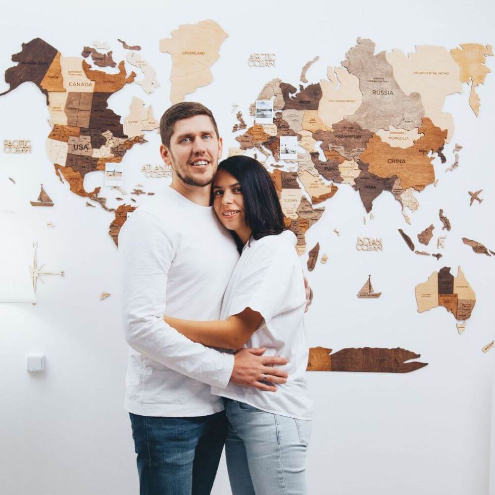
Natural Color Maps
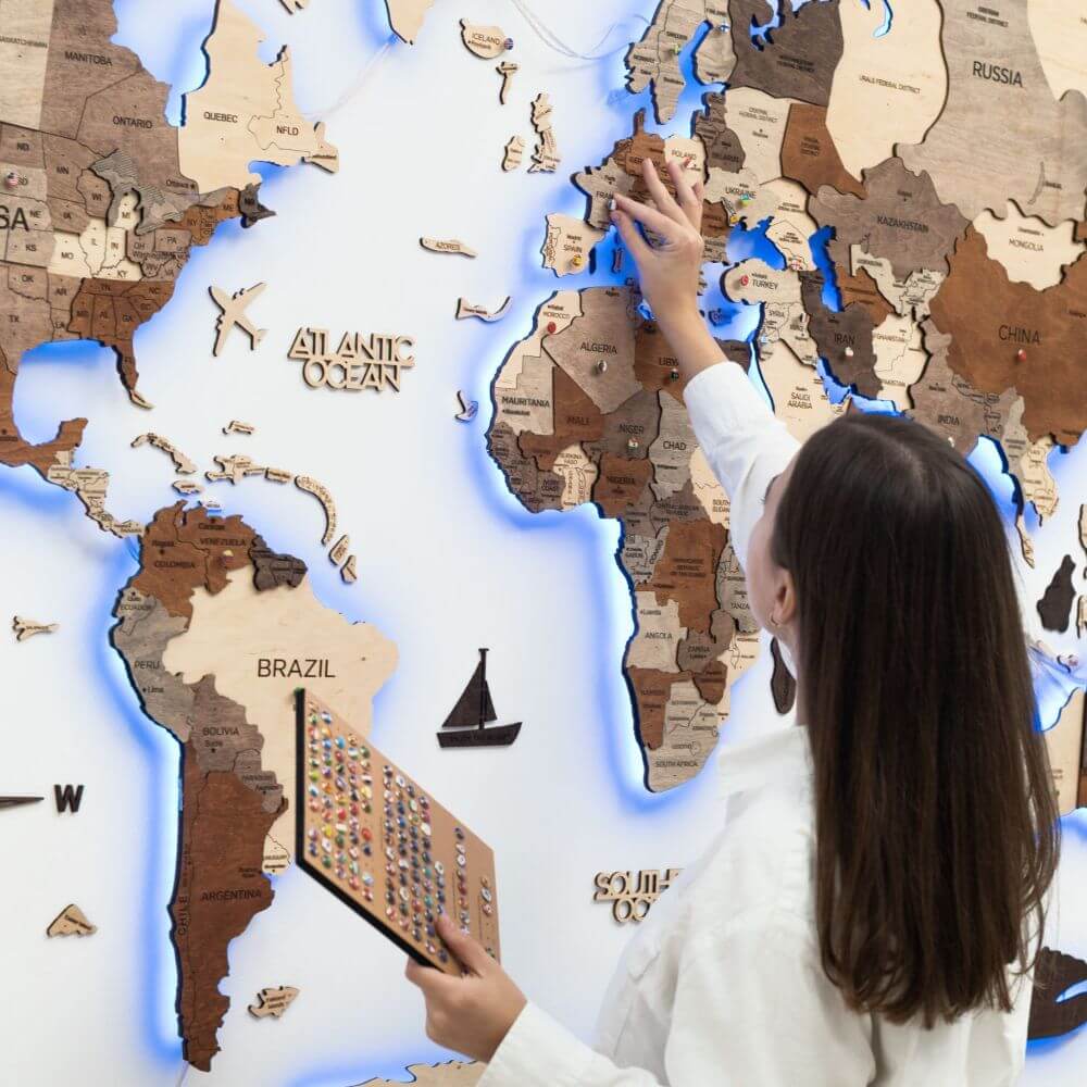
Printed Color Maps
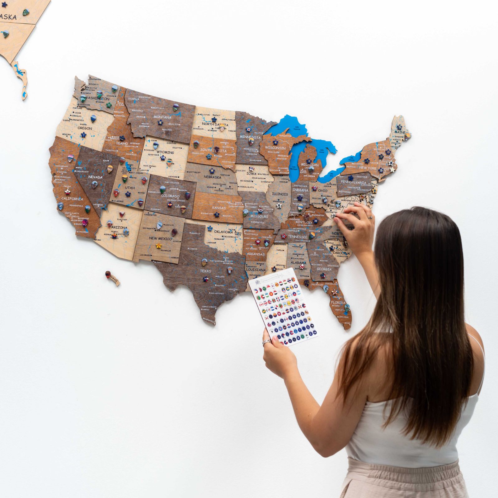
OUR BESTSELLERS

OVER 5000 5-STAR REVIEWS
DECOR THAT MAKES A DIFFERENCE

WHY YOU'LL LOVE WOODEN WORLD MAP FROM ENJOY THE WOOD
100% Unique Expert Craftsmanship
Buying unique décor at Enjoy The Wood company is synonymous with quality of origin. Shop for the very best in unique and custom handmade décor pieces!
Standout Quality
Treat yourself to top-quality, incredibly realistic, and artfully illustrated wooden world map wall decor. Excellence confirmed by ⭐ 20,000 positive reviews of satisfied users!
Style Making a Difference
Patent quality Enjoy The Wood maps pair well with all existing designs, adding an extra wow factor the any interior. From styling interior advice to helping you pick a specific wooden wall decor, our advisors are ready to assist.
Tailored to You
We can customize a wooden world map wall decor to your style. We can change the size, add details, add personal info, and do all kinds of personalization. Our craftsmen have loads of ideas. Just ask!
All-In-One Purchase
Enjoy The Wood world map makes a standout interior spot. Express your style, plan your next trips, track previous adventures, or get an investment-worthy Enjoy The World wooden map as a gift!
RELATED POSTS
WELCOME TO OUR BLOG. Get in touch.

Discovering Excellence: The Uniqueness of Enjoy The Wood's Original Products
On This Page: The Essence of an Original Product Enjoy The Wood's Originality and Legal Confirmation The Day the World Saw the First Enjoy The Wood Map How to Identify Scammers Opting for Enjoy Th...

Enjoy The Wood at TOP 100 USA Awards
On This Page: Enjoy The Wood at TOP 100 USA Awards Enjoy The Wood: The Fostenko Family Goes Above and Beyond at TOP USA Awards The TOP USA Awards 2023 was successfully held, celebrating the amaz...

3D Wood Maps Manufacturing by Enjoy The Wood
When it comes to Enjoy The Wood manufacturing, it’s not just about in-house production. It’s about crafting a memorable customer experience that embodies comfort, elegance, and a chill vibe. We’re ...
MORE ARTICLES
Enjoy the wood is happy to provide.
These wooden maps are full of travel and destination ideas. We also provide fast worldwide shipping, a lifetime warranty, our support, a unique affiliate program, and an AR app to try the map on your wall and see how great it looks! What's next on your bucket list? To sum up the benefits of these highly sought-after maps, we have just 5 words left:
MESMERIZING

INSPIRATIONAL

EDUCATIONAL

SUSTAINABLE

A Wooden World Map will be kept in the family for generations to admire. Whether you have planned to acquire this amazing map for a while or it's an impulse purchase, you will be happy you got world map wall art. Enjoy life, Enjoy the map and Enjoy The Wood!
Going Awesome Places
Detailed itineraries + travel guides
Best World Map With Pins For Travelers At Home
Last Updated September 12, 2024 William Tang
You are here: Home » Shopping » Best World Map With Pins For Travelers At Home
As travellers, we’re always seeking to bring a slice of our adventures, experiences, and ultimately our memories home. We do it by collecting things like magnets and pins, and we also trinkets small and large to display proudly at home. One way of bringing the world home is by putting up a large world map with pins as a great way to visualize everywhere that you’ve been and everywhere that you still want to go.
While you’d think that there are many options out there, they’re more elusive than you think. To make your choice easier, I’ve organized the top world map with pins products out on the market today.
In This Article
Why pins on world maps, #1 pin adventure map, #2 wooden world map (enjoy the wood), #3 water colour hand drawn world map, #4 palomar pinworld (now called dearworld), #5 customizable canvas world map, #6 framed push pin travel maps canvas, #7 world map cork board kit, #8 burlap world map with mini pins, #9 peel off world map, frequently asked questions, read more on travel must haves, travel resources for your next trip.
You might be wondering why pins specifically? Yes, I recognize that there are regular maps that you can purchase and the ones that you can scratch off as you travel. These are a fun way to start but I think ultimately they’re not the display piece you ultimately want to display at home.
With regular maps, you can’t pin anything on it unless you’re fine with a cluster of holes on your wall. With the Scratch the World Travel Map, it’s actually more difficult to scratch the map cleanly and you’re kind of limited to scratching out countries as opposed to marking somewhere specific or perhaps marking places differently based on where you’ve been and where you want to go.
Top 9 World Map With Pins You Can Buy

The two best market places to find these are either in a commercial market place such as Amazon or in the artisan space of Etsy. I’ll provide examples of high quality products from both sides and a few others vendors that are a bit more difficult to find.

If you’re looking for a high-quality, detailed, framed map, look no further than Pin Adventure Map . I recently upgraded from my old Palomar Pin World (see below) to this one in my home office and I am impressed with how well-built and designed this world map with pins is. It looks absolutely stunning.
The specific one that we have is the Framed World Map with Push Pins in Glacier with a Wedgewood French Cottage frame. That said, there are so many different designs to choose from.

First, let’s talk about the map quality itself. I am blown away by how high of a resolution this print it. As you run your fingers through the map, it’s completely smooth and even when you put your nose right up to it, you don’t see any ink dot-type pixellation.
Make no mistake, this is a geographically accurate and up-to-date world political map that was designed in partnership with a professional cartographer. I love how it not only marks countries, states, capitals, and major cities, they also highlight lakes, rivers, tallest mountains, and even special locations such as Challenger Deep. You’ll also find accurate mapping of the ocean depth.
Next, you’ll find the Glacier model to be just visually stunning especially after you start pinning locations with the coloured push pins that are included. It adds another dimension to the artwork, and there’s something about that hue of the ocean blue against the grey and white that looks so modern and slick. I also love the Wedegwood French Cottage frame that I picked which adds a rustic and textured feel to it and has its own blue threaded into the wood.
You’ll notice as well that I’ve been able to customize the map. This is part of their personalization service. You can ask them to use one of their preset designs but if you have a special request, don’t hesitate to ask. That’s how I was able to get the Going Awesome Places logo on there!
Lastly, the ordering process was a cinch. Pin Adventures ‘ customer service is friendly and swift. I also loved how they provided previews of the map for approval before printing it.
Pin Adventure Map is a member of 1% For The Planet Movement .
PRO TIP: Even at the 40″ x 53″ (100 cm x 135 cm) size, it is incredibly light and since it only comes with two hanging brackets on either end, tie a metal wire in between them so all you have to do is use one of these nifty picture frame hangers on your wall. It can definitely support its weight.

WHAT YOU NEED TO KNOW
Price: Small $241 USD, Regular $368 USD, Large $623 USD
Sizes: Small (24″ x 32″ / 60cm x 80cm), Medium (30″ x 40″ / 75 cm x 100 cm), Large (42″ x 53″ / 100cm x 135cm)
Other options: Customizable map banner or quote and select from a variety of classic or French-cottage frames. You are able to integrate personalized banners. Lastly, there is also the option to include or not include Antartica (not a purchase option on the page but you can request it or they may ask you as well). This includes 90 pins where you can choose 3 colours. They also include stickers as well.
Material and process: Fine art paper, wooden frame, pin board base, fade resistant ink.
Advantages:
- High-level of detail on the map – Yes, South Sudan is there and so have changes in countries names such as Swaziland to Eswatini.
- Shipped via DHL and well-packaged to prevent damage.
- Excellent customer service.
- Uses standard push pins that can be purchased easily as needed.
- Very light and easy to hang.
- Tons of personalization options.
Disadvantages:
- Doesn’t have a cork backing so some force is required to punch the pin through the map.
- More expensive than some other options (remember to use the Pin Adventure Map coupon code, PINADVENTUREMAP15 , to save 15% on framed and canvas maps).
Alternatives:
- There are close to 50 different styles and designs of maps available to choose from.
- Instead of world maps, you’ll also find maps specific for Europe and United States.
BUY FROM PIN ADVENTURE MAP

For the last one in this list of world maps with pins, I present to you a map that’s not constrained to paper. This world map is constructed by wood and creates a 3D jigsaw of countries where you can insert your own airplane pins for all the places that you’ve been.

If you’re looking for a travel statement piece at home, this is it. The vendor, Enjoy The Wood , on Etsy makes this completely out of birchwood plywood and is so serious about it that they even have a patent for its design.
They’ve gotten so big that they also sell directly on their own website as well .
Depending on where you want to put this in the house or office, you’ll have plenty of sizes to choose from including your choice of a map without names and borders, capitals identified or without.
At first, I thought there’d be no ways that pins could be involved but due to the softness of the wood, they’re actually designed with them in mind. That’s why you can order these with your choice of either 30 airplanes, 60 airplanes, or country flag pins. Double-sided tape is included to help mount the wooden map onto your wall.
Use our link below and code WILLIAMTANGUP to get 10% off. You’ll also get a free Wooden Flag Push Pin pack with every order.
Price: Medium starts at $96.50 USD, Large starts at $197.50 USD, XL starts at $298.50 USD, and XXL starts at $497.50 USD.
Sizes: Medium (100 cm x 60 cm / 39″ x 24″), Large (150 cm x 90 cm / 59″ x 35″), XL (200 cm x 120 cm / 79″ x 47″), XXL (300 cm x 175 cm / 118″ x 69″)
Other options: Beyond the sizes you can choose the 3 different styles of map (completely not labelled, country labelled, or country labelled with capitals identified). You can also choose what pin package you want (30 airplanes, 60 airplanes, or country flags). Languages can be customized as well
Material and process: Wood carved and engraved
- Wood material is durable and strong
- Natural 3D effect that really makes the map pop especially with the different depths and colored wood
- A WOW item to display in any room
- Since this is a large product, you do have to be careful about customs and duties but the sellers are very transparent about this
- Pins on the wooden map are permanent so you do have to be careful about your choices
- Lots of double-sided tape required to mount onto the wall
- More installation work required since you have to install pieces one at a time like a puzzle
Alternatives:
- Slightly different wood-based design but also quite beautiful 3D wood world maps
BUY THE 3D WOOD MAP (Coupon Code Automatically Applied)

This is a beautiful printing of a hand-drawn rendition of the world map that has a gentle water color quality to it. Printed on smooth matte paper and mounted onto a thick cork backing, this is the kind of world map with pin that you’d be proud to display at home. You can either frame them or hang them as they are.
These are handmade from Montreal, Canada by the Etsy vendor BalticClub . The also come with 50 black pins and a few colored ones.
Price: Small $56.22 USD, Regular $104.95 USD, Large $172.41 USD
Sizes: Small (18″ x 12″ / 45.7cm x 30.5cm), Regular (24″ x 16″ / 61 cm x 40.6 cm), Large (36″ x 24″ / 91.5 cm x 61 cm)
Other options: Comes in English or French
Material and process: Matte Cardstock 142 lbs and dense cork sheet 1/8″ / 3mm., inkjet-printed
- Thick stock paper and durable
- Uses standard pins that can be purchased easily as needed
- Cork backing which means you can push the pins straight through
- No alternative colorways
- They also have a PinCountry product that is country-specific
USE CODE GOINGAWESOMEPLACES TO SAVE 10%

This one is elusively difficult to buy especially in North America. I ended up purchasing this in the Netherlands in one of those fun art gallery stores that you can find in Europe.

The Palomar PinWorld (now rebranded to Palomar DearWorld ) is designed specifically to be a wall map diary. When I saw this tag-line, I knew immediately that this was the one I was looking for. This is a screen-printed map on coloured felt. It has a simple and modern aesthetic that I know many of you will like.
I have this mounted with double-sided tape in my office and have since purchased additional pins as well. I love the look of this map because they use a felt material instead of cork which gives it a different look. I also love Palomar’s custom pins which actually resemble destination pin markers that you find on say, Google Maps, and other mapping tools.
They have many authorized resellers around the world but chances are you’re not close to one. Your best bet is to pick this up from a reseller on Amazon . Another store that sells this is A Touch of Modern . You can also search for the term “Palomar – Pin World Map” for more targeted results.
For additional pins, I oddly had luck at a local art store so definitely search around.
Price: $98.58 USD Standard, $44.50 USD Mini
Sizes: Standard (124 cm x66 cm / 29″x 26″), Mini (77 cm x 48 cm / 30″ x 19″), XL (198 cm x 124 cm / 78″ x 49″)
Other options: Comes in Black or Light Blue
Material and process: Felt, screen-printed
- Unique design that has not been replicated by any other companies or Etsy creators
- Beautiful pins and simply screen-printed design
- Felt material means that you don’t need to be that careful pinning because they don’t leave visible holes afterwards
- Love that the felt works with velcro which makes mounting quite easy
- Limited colours (Black and blue)
- Pins are difficult find when you need more
- If you mount with Command Picture Hanging Strips as I have, you’ll notice that it droops and flares out in certain areas so it doesn’t sit perfectly flush
- There are some strange spelling errors such as Adis Abeba for Addis Ababa.
- Felt backing means that you need to insert the pins on an angle
BUY PALOMAR PINWORLD

The beauty with purchasing from vendors from Etsy is that you have much more customization and personalization options than if you were to buy it from a store. This product is by CanvasVows and they offer a canvas-based world map with pins. While the base map remains the same, you have the opportunity to change:
- Text that appears on the map (names and/or quotes)
- Background color
- Map type – world or country
- Push pin colors
The product comes with 100 pins and is ready to mount. They also create two digital proofs for approval.
Sizes: Small ( 40.6 cm x 76.2 cm / 16″x30″), Medium (50.8 cm x 101.6 cm / 20″x40″), Large (61 cm x 122 cm / 24″x48″, Extra Large (76.2 cm x 152.4 cm / 30″x60″)
Material and process: Canvas printed
- Many customization options
- Standard push pins are used and easily obtained if you need more
- As a canvas, there are many sizes available including larger formats
- Canvas provides a premium textured feel
- Durable print
- There are customization limitations including the font and size of country names
- Canvas mount means that there won’t be a solid backing for the pins to go on
- Pin holes created are permanent so you will need to do this carefully
- Digital files for the customization
- Paper prints (not mounted on canvas)
BUY CANVASVOWS

If you’re looking for a framed look, this is an excellent option to give it that polished look in whichever room you decide to hang this in. This takes advantage of the canvas print but takes it to the next step of mounting it in a wooden frame. Another thing to pay attention to this map is that it is a more accurate and detailed map compared to the others. Where others aren’t very detailed, this is one that looks to be straight from the atlas

Despite this being a product sold on Amazon , they also offer customization options. You can choose what type of wood frame you want and you can design the map with an option pin legend and personalized text.
The map comes with 100 push pins (a mix of red, white, and black). It also comes with wire hanging kit so it is wall-ready
Price: $189.99 USD
Sizes: 100.3 cm x 69.9 cm / 39.5″ x 27.5″ (width x height)
Other options: Wood frame colour (6 colours to choose from)
Material and process: Canvas printed and dry mounted to foamcore board
- High quality and durable printing on Canvas
- Detailed map
- Lacking of different map designs to choose from
- One size only
- Beyond this product, they actually have a really extensive set of products that vary from map, mounting-style, and print-style
- They also sell 3-Panel Canvas Wraps , Full Canvas Wraps (but not framed), and Framed Paper Maps
- It looks like they have an Etsy store with even more selection.
BUY PUSH PIN TRAVEL MAPS

If you’re looking for a more comprehensive kit, this cork board world map with pins is an excellent choice. From a style perspective simple with a screen-printed map on a cork board but what I like about it is that it’s framed so it’s easy to mount on the wall and it comes with a collection of custom pins that allows you to tell your own story when it comes to your world map diary of your travels. There are 3 packs of flags that you stick around metal pins – one for flags, a second one for monuments, and another foods of the world.
The World Map Cork Board Kit comes in either black or white and two large-format sizes. The pin kit includes 194 different country flags with 100 sticks, 64 food stickers, and double-sided tape hangers for an easy installation.
Price: XL $87.97 USD, L $44.97
Sizes: XL (60 cm x 90 cm / 23.6″ x 35.4″), L (45 cm x 60cm / 17.7″ x 23.6″)
Other options: Black or white color, and framed or not framed (framed option only for XL size)
Material and process: Map screen printed on sustainable cork oak forest from Portugal
- Screen printing on cork is more forgiving allowing you to pin around without worry of leaving holes behind
- Lots of space on the cork for creative pinning to be able to tell your travel story
- Print on cork may not be as durable
- The adhesive provided for mounting non-framed map is not recommended
- There will naturally be a limitation of the number of pins in the kit so once you run out, you’ll have to use alternative pins
- Not customizable
- There is a different design available that looks more like a Magellan explorer map of old
- They also have a map that is USA specific
BUY THE KIT

Looking for something a little bit smaller or perhaps use at a wedding? This cute framed, world map printed on burlap is an awesome way to highlight all of the places you’ve been to around the world.

The barnwood frame is naturally weathered and enhances the rustic feel of the push pin travel map.
The world map is mounted on 1/4″ cork and is ready to hang on your wall. It also comes with 50 red small push pins.
You can get a 15% off coupon if you sign up to their mailing list .
Price: $72.25 USD except for the barnwood frame which is $76.50 USD
Sizes: 28 cm x 36 cm / 11″ x 14″
Other options: There are 6 templated phrases but this can be fully customized and there are 6 different frame colors to choose from
Material and process: Screen printed on burlap with laminated backing and mounted on 1/4″ corkwood backing
- With the burlap material, you won’t have to worry about leaving leaving permanent holes on the pin
- Customization possibilities in the text
- Most cute and rustic out of the whole group
- This is a small map compared to the others here
- Due to the smaller size, smaller pins are required and may look very clustered if you have travelled to many destinations
- Map is missing Antarctica
- Burlap material is laminated but over time may show some wear and fraying of fabric if manipulated frequently
BUY THE BURLAP MAP

We’ve all seen the scratch off world maps and the reason why I haven’t included any so far in this list is because they don’t have come with any pins.

I’ve added this one by BoldTuesday as a bonus feature because I really love the minimalistic look to this world map and the fact that it’s a peel off vinyl sticker which is so much easier (and much cleaner).
To turn this into a map with pins, all you have to do is get a little creative and pick up one of these map pointer vinyl stickers which will most certainly pop from the black.
Price: Poster-only is $44.30 USD, Poster with Hanger is $63.21 USD.
Sizes: One size: 70 x 50 cm (28″ x 20″)
Other options: None
Material and process: 3M matte, quality vinyl
- Minimalist look that easily matches all types of decor
- Peel off vinyl stickers for countries visited
- Mounting kit with the hanger is convenient and clean
- No mess when peeling off countries compared to scratch off maps
- Secondarily, you can store all of your peeled off/visited countries in a diary or separate booklet (not included)
- No built-in or included pins (need to purchase separately )
- As with other maps, small countries (i.e. Pacific Islands) will not be marked/peelable
- Only one color (black/white)
- Only one of its kind so far.
BUY THE PEEL OFF MAP
Tips on pinning your world map
These are my top 5 tips for pinning your map based on my experience with the Palomar PinWorld and Pin Adventure Map .
- Think carefully about where you want to mount/hang your world map
- Before you start, have a plan for how you want to pin the map – Will you have a different pin colour to identify which family member has been where? Will you differentiate between where you have been and where you want to go? Will you mark cities, or just countries?
- For the maps with materials where pins are more permanent, make sure you pin carefully
- Stay up to date! It’s easy to forget to do this once it’s up on the wall. Every once in awhile, find out where you’re able to add more pins
- Get creative with your map. You’ll be using a ton of push pins but what about using other types of pins or perhaps creating something on your own?
Looking for more pins?
The more you travel, the faster you’ll run out of pins. When that happens, you’ll want to have these handy links ready so you can stock up.
- 100 Assorted colours round push pins – These are the AmazonBasics versions that come in a pack of 100
- 600 assorted push pins – Best value price out of this entire lot
- 300 map push pins – The same style of pins but just more quantity and you can pick any 3 colors you want
- Metal airplane push pins – These are from the wooden world maps but could be used for any map
- White metal airplane push pins – Push pins in the shape of paper planes in white
- Metallic bead head push pins – For a more glam look to your pins, you can grab this pack of 800 that will be sure to last you awhile
- Gold push pins – Add a splash of gold to your maps
The Pin Adventure Map makes an excellent gift with their gift wrapping and customization options.
Maps come with a limited number of push pins to start but since most of them use standard circular pins , they’re easy to find online when you need more. The only exception is the Palomar PinWorld which has their own custom designed pins.
Many of these maps can be personalized and customized for display in your home or use in special events such as weddings. These will come at a small extra fee. Good examples of customizable ones are Pin Adventure Map , CanvasVows , Push Pin Travel Maps , and Burlap World Map .
The only map that is completely geographically accurate are the ones by Pin Adventure Map . The larger the map, the more detail they can put in as well. Others are mostly country-based outlines and high-level markings.
I’d love to hear about your experiences with world maps with pins. Have you find a different one not on this list that you’re really happy with? How have you creatively set them up? Leave a comment below to share.
- Travel virtual experiences you need to check out
- Awesome Etsy gifts for travellers
- What do you collect when travelling?
- Gifts that travellers actually want
- Inspirational wanderlust quotes with pictures
- Our best travel gear & tech articles
If you’re in the process of planning your trip and putting together your itinerary, these are genuinely the best resources that the Going Awesome Places team stands by 100% .
Credit cards: Don’t get burned by hidden fees on top of terrible exchange rates. When we travel now, we use the Wise Card . Simply load it with the currency you need before you go and use it as a regular VISA or their digital wallet card. Use their free app to track how much you have and top up when you need to.
Flights: Of all the booking search engines, Skyscanner is the most helpful and easy to use thanks to their Everywhere feature . Kayak is also another that’s we will often check as well.
Car Rental: If you’re looking to save money, these car rental coupon codes will be a true game-changer. Otherwise, DiscoverCars and RentalCars are great places to start.

Airport Parking: You’ll need a spot to leave your car at the airport so why not book a spot at a discount. Use code AWESOME7 to get at least $5 off at Airport Parking Reservations or Park Sleep Fly packages.
Wifi Hotspot: We’ve been a huge fan of wifi hotspot devices such as PokeFi (use code GAP24300 ) because their rates are are hard to beat and it works globally. Solis is another that we recommend. Pros are that you can share the wifi with your whole group but cons are that you have to invest in a device and you have to charge it every night.
eSIM: Lately, we’ve really loved using eSIMs. We’ve tested several over the years and we have access to a few special promotions.
- AloSIM – Use code GOINGAWESOMEPLACES to save 15%
- KnowRoaming – Use code GAP10 to save 10%.
- Airalo – Use referral code WILLIA9500 to get $3 USD credit on your first purchase.
- Ubigi – AWESOME10 to save 10% on your first order.
Hotels: Our go-to is Booking.com because they have the best inventory of properties including hotels and B&Bs plus they have their Genius tier discounts . Expedia is also worth using especially with their One Key rewards program which is basically like cash. The exception is Asia where Agoda always has the best prices. Always do a quick check on TripAdvisor as well.
Vacation Rentals: Your first instinct will be to check Airbnb but we always recommend checking VRBO as well if you’re looking for a vacation rental (now eligible for One Key ).
Tours: When planning our trips, we always check both Viator and GetYourGuide to at least see what’s out there in the destination that we’re going to. They often have different offerings and prices so check both.
Travel Insurance: Learn how to buy the best travel insurance for you. This isn’t something you want to travel without.
- HeyMondo – Popular insurance provider for frequent travelers and comes with great coverage and special perks.
- RATESDOTCA – Search engine Canadians looking for the cheapest insurance including multi-trip annual policies.
- SafetyWing – A perfect fit for long-term nomads.
- Medjet – Global air medical transportation.
- InsureMyTrip – Best for seniors, families, and those with pre-existing conditions.
If you need more help planning your trip, make sure to check out our Travel Toolbox where we highlight all of the gear, resources, and tools we use when traveling.
- Facebook 12
- Pinterest 129
About William Tang
William Tang is the Chief of Awesome behind the award-winning Going Awesome Places which is focused on outdoor adventure, and experiential travel. His true passion lies in telling stories, inspiring photography and videos, and writing detailed itineraries and travel guides. He is a member of Travel Media Association of Canada (TMAC), Society of American Travel Writers (SATW), Adventure Travel Trade Association (ATTA), and Travel Massive. He has also been featured in publications such as Reader's Digest, Entrepreneur, Men's Journal, and Haute Living. Make sure to learn more about William Tang to find out his story and how Going Awesome Places started.
Leave a Reply Cancel reply
Your email address will not be published. Required fields are marked *
Save my name, email, and website in this browser for the next time I comment.
Find us on social media
- Travel Maps
- Business Maps
- Build-A-Map
- Games and More

Push Pin Travel Maps
- World Maps: Push Pin, Prints, Framed
- World Maps: Kids
- World Maps: Historic
- World Map Wallpaper
- USA Maps with National Parks
- USA Political Map
- USA Map for Kids
- USA Sticker Maps
- USA Map Wallpaper
- Motorcycle Road Trips
- Theme Parks Map
- State Maps: Topography
- State Maps: Labeled
- State Maps: Historic
- Baseball Maps
- Basketball Maps
- Football Maps
- Hockey Maps
- Grand Tour Maps
- Racing Maps
- Sports Map Wallpaper
- Airport Maps
- Caribbean Maps
- Cities: USA
- Cities: World
- Country Maps
- Europe Maps
- Historical Regional Maps
- National Parks
- Satellite Maps

- Business Wall Maps
- Custom Wall Paper Maps
- Custom Push Pin Maps
- Electric Power Transmission Grid Map
- GIS Posters
- Environmental Art
- Case Studies
- Hotel Wallpaper
- Interior Designer Wall Art
- Restaurant Wallpaper
- RV Wallpaper & Maps

Find the perfect map, and personalize it just for you with our map builder tool!

- Explorer Cards Kids USA Adventure Game Bundle Educational Materials National Park Sticker Maps Push Pins & Accessories Gift Cards

- Custom Examples
- Frame Gallery
- Canvas Maps
- Sports Maps
- Coordinating Maps
- Map Posters
- Map Wall Decals
- GIS Services and GIS Wall Maps
- Printing Services
- Wholesale Maps
- Wall Art Consulting
- Educational Resources
- About GeoJango
- Interactive Map Catalog
- About Our Maps
- Map Finish Options
- Map Comparisons
- Hanging Instructions
Read Our Reviews!
Quality guaranteed, free shipping on maps over $50, expert cartography.

Personalized world travel maps with pins - track your travels and tell stories of your adventures with our world maps, labeled for exploration. Discover new places, historic facts, ocean currents, countries, lakes, deserts, and a myriad of cities for you to plan your next journey. Add your family names with a custom legend, or business logo, to craft a perfect one of a kind gift. Use colored pins to track where you've been and where you'll soon explore!

I just gave this gift to my best friend tonight for her birthday. She absolutely loved it! The quality is great, the seller was awesome to work with and very friendly!

I hung our map up in the Bisbee Visitor Center and it has been a huge asset! People from all over the world are placing their pins in their home towns.

We love the NHL map personalized for me and my daughter as we start our Arena tour. High quality and looks awesome in her bedroom! Go Devils!!

Such a fun special gift! The process of personalizing the map was fun and very user friendly. The map was packaged beautifully for shipment. Customer service was excellent. And most important, it is a gorgeous, personalized, nice quality map.

I absolutely love my map. Love that it is detailed with my name and others have noticed it and think it’s super cool.Will definitely order here again for family or friends. And will recommend them to shop here as well. Pining all my trips and Indy Car tracks I’ve been able to go too. So much fun. Can’t wait for future travels!

Perfect perfect perfect perfect

We love our world map! It looks awesome above our couch in the family room. We are very happy with the largest size. What an educational treasure!

I absolutely love it! It’s better than I thought it would be. Great quality!

Just hung up our new, beautiful, and very detailed canvas wrapped map in our new game room. Excited to get started adding our colorful pins to display our years of previous travels. And really eager to hit the road to add our new favorites places on our map as we expand our "Explore America" adventures!

We have been wanting to order this map for quite some time!! We LOVE it! It arrived quickly and was packed EXTREMELY well!! It’s up on our wall and now we can clearly see the parks we still have left to explore!! Thank you so much for a beautiful, quality product!!

Our customized world map is a perfect addition to our living space! It brings back fond memories of places we visited and inspires us for future travel. I can’t wait to start changing the pin colors from wish list to conquered!

Absolutely lovely!

Push Pin World Map
Your world travel pin board will help you travel more. We craft the most detailed push pin maps, featuring labels designed to help you learn more about the world, to plan adventures and pin where you've been.

Your Story, Your Pins
One lifetime is not enough - exploring the world is adventure to be shared. Pin maps help you tell your story, and inspire conversation with everyone that a push pin travel map enables you to share it with.

Spreading the Joy of Travel
Explore the world with expert cartography - the product of 30+ years of passionate geographic research backed by Master's Degrees in Geographic Information Systems (GIS) from Penn State University and Environmental Science from University of South Florida.
We make the best maps, leveraging the beauty of geography to craft comprehensive labeled travel maps that are kept current with world events for all the thousands of locations we feature. Having one in your home will inspire you to travel more, and ignite conversation with everyone that visits!
Travel Maps with Pins
What sets our push pin map apart: We are professional Geographers and GIS Scientists, and we take extraordinary time to make beautiful, accurate, comprehensive maps. Our maps feature real bathymetry , cultural references, landmarks, historical voyages, UNESCO World Heritage Sites, and much more! This enables you to tell your story as you pin your travels, tracking where you've been and where you aspire to go.
Explore the world with a framed pin board map or beautiful stretched canvas wall art. We invested in the best equipment and built the nation's best push pin map production center to ensure that your personalized map will last a lifetime. Our push pin map studio is located in Pleasanton, California, USA, where we produce museum-quality fine art maps, made to order just for you.
Our maps are designed as reference maps of the world — to visualize the geography of our planet — from countries, cities, oceanography, and more. Fine-Art Map Production Studio : We produce all of our maps as fine-art, museum-quality works. We use premium materials for rich color depth and select the best media that are ideal for the details inherent to maps. After all of our research and work in cartography, only the best printing production is acceptable. We built the finest Map Studio in the USA to produce our maps. To best display the intricate details and labeling we crafted over months and years, we tested hundreds of materials, found the best ones, and invested in high-performance printing equipment so that the inks and materials will resist fading over time. We have developed a dedicated environment that is essential for our top-quality maps.
All of our framed and stretched canvas maps are built as push pin maps and mounted on high-quality pin boards. Every map is embedded into the pin board for a permanent bond that will not separate. We found the highest quality boards that will not warp over time. In our research, we discovered lesser quality constructions tended to cup, curl, and warp in normal conditions. Our maps are beautiful pieces of archival cartography that will continue to show Earth's natural beauty and complexity over the span of decades. Use pins to mark places you have visited, plan to visit, or highlight your family heritage, making every push pin map a personal journey. If you are looking for a unique and personal way to track your travels, or a gift to give to others, our cartographic and geographic details are the top notch in every map. To top it off, we assist with custom touches and have a number of customization styles to suite everyone's tastes and preferences.
Learn With Labeled World Maps
How many countries are there in the world.
In 2024, there are 193 recognized countries in the United Nation’s official geographic database . The United Nations is an organization of independent States that was formed in 1945 under a Charter to promote and maintain international relations and peace. In addition to UN member states there are 2 non-member observer states: the State of Palestine, and Holy See, bringing the total to 195. Additionally there are quasi-states that meet the criteria for statehood, but not recognized by other states, such as Taiwan / Republic of China and the People’s Republic of China.
A country is an area of land with recognized boundaries and unified by one central government. The government represents the nation of people. Generally, the four characteristics of a country include
- an area of land that is defined by borders
- a permanent population
- a formal government
- sovereign territory that is diplomatically reinforced by one single independent government.
However, what specific areas constitute a country is an ever-evolving debate, with various regions claiming independence to varying degrees of recognition around the globe. The Holy See and Palestine, notable as UN observers, have wide recognition though are not UN members. Areas of disputed sovereignty have less recognition, such as Taiwan and Kosovo, which change over time.
Our world maps represent all of the countries using the United Nations geographic database. However, there are many constraints when displaying the world as a flat rectangular wall map in a very small scale. The Earth covers 196.9 million square miles (510 million kilometers). Using GIS technology, we can reduce geographic features to a fraction to enable the visual display as a wall map. When appropriate, we must take measures to prioritize details in a map where labeling may obscure the visibility of the geography. We prioritize the visualization of features to enable a perspective of the location, size, and shape of areas. We apply comprehensive and modern projections that eliminate large exaggerations of lands such as Greenland when the Mercator projection is applied. Using two parallels at the 45-degree latitude on both the northern and southern hemispheres, we can optimize the visualization of the major bodies of land. Our projections are designed to prioritize the shape and area of land to maximize our visualization.
We make our maps at our studio in Pleasanton, California, USA. These are our works of art, and we craft each one to order - we do not keep stock products in inventory.
Each map is a product of years of research and design. We love the opportunity to combine science and art in these wonderful travel maps, and we especially love personalizing them just for you!
Your map will be produced to your specifications using our archival quality materials and fade-resistant inks on large format printers. If you choose a poster in canvas or paper it will be rolled and mailed to you. For ready-to-hang options in framed or stretched canvas, we will mount your map on archival quality pin board and include everything you need to start pinning and build lifelong memories.
We do not use foamcore or cork backing - the gatorfoam we mount pin maps to is a premium archival quality rigid material that will not warp over time, bend away, or crush as you pin your travels. Your pins will be held tight for a lifetime. This material also enables us to offer you incredible clarity with satin paper options that have a smooth finish, in addition to our canvas offerings.
Our canvas wrap and framed maps include premium hanging hardware as well. You will find the pre-installed rigid hangers make it easy for you to hang your map and keep it solidly level, and no guessing or measuring where to drill like for a wire!
USA Travel Maps

Cartography: Geographic World History
Learning geography and world history is an inherently intertwined process. As political and social movements lead to shifts in land ownership, the creation of new nations, and the redrawing of boundaries, these changes are meticulously documented through surveys and record keeping. Historical events, from wars and treaties to exploration and colonization, directly influence geographical demarcations, thereby shaping the world map as we know it today. Meanwhile, the geographical context often plays a pivotal role in understanding the causes and outcomes of historical events, such as how mountain ranges have served as natural fortifications or how river valleys have cradled early civilizations. We invite you to explore the largest lakes in the world and learn about the physical geography of their formations as well as their bordering countries using GIS technology. Together, the study of geography and world history provides a comprehensive view of humanity's footprint on the Earth. In our maps, we point out unique sites around the world that typically are not on most maps, yet these significant locations, such as the current 7 wonders of the world , are only a few examples. Using travel destination guides , interviewing world travelers, and through dedicated research, we highlight special sites around the world. Gifts for travelers, history and geography fans alike, would enjoy exploring our Gallery of World Maps and Explorer Cards .
Our Travelers Also Loved
The details matter: Our products are created by a professional Geographer and Cartographer who has the passion and experience, including Master's degrees in GIS and Environmental Science, to create impressive maps for your home or office. We understand the massive amount of accurate information necessary for a great map, so we highly recommend our maps — professionally designed with GIS.
The main differences are the colors and cartographic styles. The informative details (labeling) are the same throughout the maps with a few exceptions:
The Voyager 2 includes snow/ice modeling. We use the MODIS satellite data collected in February to show the snow/ice cover on the landscape, which you can see represented in white in the northern hemisphere.
The Voyager 1 excludes the snow/ice modeling, so you can visualize the elevation and landscape of the terrain that lies beneath the snow cover.
The Magellan World Map features additional facts about Ferdinand Magellan's epic voyage around the world.
The Voyager, Nautilus, Magellan, Darwin, and Odyssey World Maps include modeling of the landscape and terrain (deserts, forests, flat lands, and more) and elevation features — which illustrate the mountainous regions. We applied a hillshade to model the sunlight at 3 p.m. consistently around the world. The hillshade provides a 3D effect. It is a flat surface — yet looks 3D due to the incredible modeling technique.
The Voyager, Nautilus, Magellan, and Odyssey World Maps include all 63 USA National Parks (as of 2024). In addition, all of these maps include renowned National Parks in several countries around the world.
The Endeavor, USS Enterprise, Humboldt, and Columbus World Maps provide a classic look at Earth without terrain modeling. Each of these maps depicts beautiful cartographic styles — from modern, sleek designs to antique-inspired designs that capture the character of old-world maps.
All of our world maps feature our unique ocean floor elevation modeling derived from NOAA oceanic data. This data illustrates the formations of islands, archipelagos, plate tectonics, and ocean currents by displaying the sea floor elevation across the Earth's oceans.
We produce all of our maps as Fine Artwork. The maps are rolled in a tube to eliminate creases and damage. You can frame the map locally or apply a pin board with a DIY mounting method that suits your abilities. The posters can also be enjoyed as wall art, and all of our products are sized to be framed with standard sized frames.
Every component of our products is made in the USA! Our maps are produced using the highest-quality printing, paper, and canvas. We use archival inks for rich color depth and fade resistance. We fix all of our framed and canvas wrap products to gatorfoam, a strong, durable material that's used in museums and designed to last for a lifetime.
Traditional stretched canvas in a gallery style wrap, with the art continuing over the sides. This format is lightweight at smaller sizes, and also is available at giant wall-spanning multi panel sizes.
The canvas is wrapped around an internal solid wood frame, premium pinboard, and is installed with our premium rigid hanging solution that makes it easy to mount on your wall.
All of our maps are handcrafted, made to order just for you, and we will work with you to craft your personal masterpiece map. Most of our map product pages will guide you through their options, but ALL of our maps can be customized. Include your quote, family names, or logo as directed, or reach out to our support for something special - we can also accept commissions for custom colorways!
All custom maps will receive a proof via email, and you will approve your proof before we print your map and begin crafting it to your specs. This will elevate your map to be an unforgettable gift, family heirloom, or personal travel diary.

World Map Poster and Framed Sizes
Our push pin maps are available in a variety of sizes, so we can accommodate any space within your home or office. Take a look at this video to see a side-by-side comparison of our sizes.
The most important factor when choosing your map is size. The World is a huge place, but smaller prints like a world map poster are easy to travel with!

Map Finish Types
- Framed satin paper or canvas mounted to pinboard
- Stretched canvas with pinboard for a frameless gallery look
- Rolled posters in paper or canvas for easy travel
- Adhesive fabric or glossy wall coverings to transform an entire space in your home

Custom Travel Map Gift
Maps are great for every age, gender, and occasion. Start an adventure, keep a push pin map as a touchable memory that can be personalized!
- Perfect for wedding gifts
- Lovely anniversary gifts
- Mother's Day Gifts or Father's Day Gifts
- Graduation gifts for those just starting out in the world
- Esteemed retirement gifts
- Bucket List
Gift Wrap and nicely assembled card available for your gift.
All of our push pin maps are mounted to archival quality pin boards. This premium, rigid material will not only hold your pins tight for a lifetime, but also provides a smooth surface that allows us to offer you smooth satin paper prints. In contrast to canvas there is no fabric weave visible, making text and other details clearer when printed at small sizes.
Canvas prints are better able to stand up to being touched, and allow us to offer the frameless stretched “canvas wrap” format at up to very large sizes.
We offer framing for both canvas and paper, and they both look incredible. From more than a couple feet away, the differences fall away, and either will earn you admiration as they hang from your wall.
- Paper: better clarity of tiny details
- Canvas: more options for sizing, better fingerprint resistance
- Framed and Canvas Wrap maps come pre-installed with unique rigid hangers, featuring an incredibly easy positioning process that'll keep your map level and steady even while you're placing your pins. Just have a hammer and some space on your wall ready. View our instructional video to learn more.
- Poster options will additionally offer hanging kits, or you can keep it rolled for easy travel, or even take it on as a project to frame it yourself.
GeoJango is committed to creating a new type of map, one that truly reflects the beauty of the world. We use accurate geographical data to document countries, cities, rivers, lakes, mountains and many other physical features. We also include historical events, ancient civilizations and significant landmarks in order to tell the story of Earth. The result is a beautifully designed push pin map that you can use to decorate your home, track your travels and learn new information about our world. © GeoJango ™ , LLC, 2024
- Refund Policy
- Privacy Policy
- Production & Shipping
- Custom Title Inspiration
- National Parks Checklist
- List of US National Monuments
- List of NFL Teams & Stadiums
- List of MLB Teams & Stadiums
- List of NBA Teams & Arenas
- List of NHL Teams & Arenas
Join our newsletter to find out about special discounts, new products, and fascinating travel destinations.
- United States (USD $)
Last Chance
Save on your first GeoJango Push Pin Map!

Travel Map Creator
Loading map..., save options:.
You can bookmark this page and it will save your visited countries.
You can also download your map into a image file:
Style Options:
Countries visited :, select countries:.
- Afghanistan
- American Samoa
- Antigua and Barbuda
- Australian Indian Ocean Territories
- Bosnia and Herzegovina
- British Indian Ocean Territory
- British Virgin Islands
- Burkina Faso
- Canary Islands
- Cayman Islands
- Central African Republic
- Cook Islands
- Democratic Republic of the Congo
- Dominican Republic
- Dutch Caribbean
- El Salvador
- Equatorial Guinea
- Falkland Islands
- Faroe Islands
- Federated States of Micronesia
- French Guiana
- French Polynesia
- French Southern and Antarctic Lands
- French West Indies
- Guinea-Bissau
- Heard Island and McDonald Islands
- Hong Kong S.A.R.
- Isle of Man
- Ivory Coast
- Liechtenstein
- Macao S.A.R
- Marshall Islands
- Netherlands
- New Caledonia
- New Zealand
- Norfolk Island
- North Korea
- Northern Cyprus
- Northern Mariana Islands
- Papua New Guinea
- Philippines
- Pitcairn Islands
- Puerto Rico
- Republic of Serbia
- Republic of the Congo
- Reunion Island
- Saint Barthelemy
- Saint Helena
- Saint Kitts and Nevis
- Saint Lucia
- Saint Martin
- Saint Pierre and Miquelon
- Saint Vincent and the Grenadines
- Saudi Arabia
- Sierra Leone
- Sint Maarten
- Solomon Islands
- South Africa
- South Georgia and the Islands
- South Korea
- South Sudan
- Switzerland
- São Tomé and Príncipe
- The Bahamas
- Trinidad and Tobago
- Turkmenistan
- Turks and Caicos Islands
- United Arab Emirates
- United Kingdom
- United Republic of Tanzania
- United States Minor Outlying Islands
- United States of America
- United States Virgin Islands
- Wallis and Futuna
- Western Sahara
Created Link:
The Best Push Pin World Maps
Explore the World with Push Pin World Maps: Unlock the power to reminisce on past travels, cherish adventures, and plan exciting future trips with the help of push pin world maps. Whether you’re mapping out your past journeys, plotting new adventures, or simply getting lost in the intricate details of the world, these push pin travel maps offer the perfect canvas for your wanderlust. Keep track of every destination and create a visual diary of your explorations with ease. Let these remarkable maps be your guide to remembering and reliving your unforgettable experiences. Ideal for home decor, these maps also make excellent gifts for travel enthusiasts. Personalize your push pin world map by adding unique markers, flags, and notes to highlight special trips and future goals.
Table of Contents
Push Pin World Maps
Push pin globes, us push pin maps.
Vintage World Map Poster

Crafted by aesthetically-driven map creators with a passion for exploration, this vintage-inspired world map poster is a testament to wanderlust. Immerse yourself in superior quality and precision as you chart your own unforgettable travel story, all in one place. For these creators, mapping the world is an ongoing adventure, fueling an insatiable curiosity. With this world travel map pin poster, no journey goes unremembered.
This meticulously detailed map accurately showcases countries, states, capitals, major cities, lakes, rivers, seas, mountains, and more. Available in two larger sizes, it offers ample space to capture every detail of your travel adventures.
Included with this wall pin map are 100 push pins and 60 unique stickers, making it ready to hang and personalize your voyages instantly. Mix and match colored push pins with stickers to create your very own dream board of exploration.
Review: 5/5
Size: 24 x 32 inches (60.96 x 81.28 cm), 40″ x 53″ (101.6 x 134.62 cm) List Price: $59.95 Buy: Click To Buy On Amazon
Gold and Navy Textured Push Pin World Map

Record your journeys and arrange upcoming expeditions on this lovely wall map poster. The gold land and the navy water have a textured look, and the map has a Country Tracker and Continent Checklist along the bottom. Travel map poster printed on premium canvas.
Capture Your Adventures and Plan Future Expeditions with our Stunning Wall Map Poster: Featuring a rich gold hue for landmasses and a deep navy tone for oceans, this textured map is as visually captivating as it is informative. Complete with a handy Country Tracker and Continent Checklist along the bottom, our travel map poster is printed on premium canvas for durability and style.
Make it Your Own: Customize your map with a beloved travel quote, your family’s names, or even your company logo for a personal touch.
Each map comes with 100 push pins to mark your journeys, with 50 pins available in each of two colors of your choosing.
Choose from three convenient sizes to suit your space: 40″x24″ (102×61 cm), 48″x30″ (122×76 cm), or our extra-large 60″x40″ (152×102 cm) option.
List Price: $99 Buy: Click To Buy On Amazon
Personalized World Map on Canvas in Vintage Earth Tones

This beautifully customized canvas world map is a striking addition to any room, offering an interactive way to record and plan your expeditions. Featuring vintage earth-tones that complement most decors, this map is printed on premium canvas for a sophisticated look. With outstanding clarity and detailed city and country markings, it’s perfect for apartments or offices. Choose from Ready-To-Hang options for immediate pinning or Rolled for customization.
Review: 4.8/5
List Price: $94 Buy: Click To Buy On Amazon
World Push Pin Travel Map with Modern Slate Style

Transform your living room, dining room, office, or nursery with this stunning world map, designed to be the focal point of any space. It boasts an internal ¼” sheet of cork, allowing you to use any type of push pin repeatedly.
Carefully selected by the creators for each map style, the recommended push pin colors enhance the map’s design with an eye for detail.
With this push pin world map, you can elegantly document your travels, creating a beautiful and meaningful display.
Review: 4.7/5
List Price: $109 Buy: Click To Buy On Amazon
Executive World Push Pin Travel Map

Capture your global adventures with a Wayfarer Push-Pin Travel Map: Crafted by the skilled cartographers at National Geographic, this print showcases a winkle triple projection of Earth with exquisite detail. Featuring delightful flourishes and traditional earthly tones, this map is ideal for those with a more classic home decor style. The print comes framed in our contemporary 1wb3 frame, boasting a square profile with a subtly convex surface, finished in black. Each framed piece is fully assembled and ready to hang, complete with 100 assorted color map tacks, rigid black backing, and pre-installed hanging hardware. Beyond tracking your travels, the wayfarer map can also be used for office or customer locations, genealogy, research, and education.
Review: 4.5/5
List Price: $77.99 Buy: Click To Buy On Amazon
World Map Poster with Pins

This pin world travel map poster was crafted by artists who are passionate travelers themselves. The exceptional quality and precision of this travel destination wall map poster allow you to create your own memorable travel story by tracking all your journeys in one place.
Printed on enhanced matte paper and laminated for additional protection, this wall push pin travel map poster accurately depicts all nations, states, provinces, capitals, major cities, seas, rivers, lakes, and more.
Complete with 90 push pins and 60 unique stickers, this world map poster comes ready to hang, allowing you to pin all your travels right away.
Review: 4.3/5
Size: 24 x 32 inches (60.96 x 81.28 cm) List Price: $59.99 Buy: Click To Buy On Amazon
Push Pin Cork World Map

This push pin map offers a unique alternative to scratch world maps . Its matte, warm finish makes it an ideal complement to your home decor. Made of cork, there’s no need for framing like with scratch maps; simply decorate it with our flag push pins.
Picture yourself tracking your travels with photos from your adventures, inspiring your next journey. This push pin world map will awaken your wanderlust and may even spark friendly competition among friends and family.
Review: 3.9/5
List Price: $34.97 Buy: Click To Buy On Amazon
Cork Globe with 50 Different Colored Push Pins

The globe features clearly delineated maps of each nation, facilitating easy location of any place on the planet.
Its base is constructed from durable stainless steel, providing strength and stability for effortless spinning of the globe.
List Price: $99.97 Buy: Click To Buy On Amazon
World Globe with Colorful Magnetic Push Pins

This world globe with a stand offers unobstructed 360° viewing, making it easy to locate any country in the world. The globe, designed for kids, is constructed with metal bearings and balls for smooth rotation.
The metal globe features clear printing and lines, including national boundaries, continental boundaries, administrative divisions of the United States, country names, major city names worldwide, as well as lakes, rivers, straits, oceans, ocean depths, and international date lines.
With over 45 major city names in the United States, this globe enhances children’s memory of city distribution and administrative divisions in the country.
The globe’s surface is writable with a marker pen and can be easily wiped off with a wet.
List Price: $39.99 Buy: Click To Buy On Amazon
Push Pin U.S. Map Board

Showcase your life’s adventures with this exceptional, high-quality travel map of the United States. Full of character, it comes with push pins included.
Featuring over 20 pin colors across all designs, including special metal vintage pieces created specifically for this map, you can customize your display to suit your style.
Built to last, this map boasts a heavy-duty wood fiber backing for push pins, an internal frame, and a stretched canvas print. It’s ready to hang and enjoy.
List Price: $109.00 Buy: Click To Buy On Amazon
U.S. Push Pin Travel Map

This U.S. Travel Pin Map is perfect for avid explorers of the United States, showcasing the country’s beauty in intricate detail. Track your past and future vacation destinations with ease using this expertly crafted pinboard map by National Geographic. Plan your holidays and road trips effortlessly with its inclusion of major highways , national parks , and cities. Plus, its antique-style color palette and rich shaded relief complement any décor seamlessly.
List Price: $139.99 Buy: Click To Buy On Amazon
Push Pin Map United States on Canvas

Capture and cherish your travel memories with a push pin travel map of the United States. Whether you want to treasure past travel adventures or ignite your wanderlust for future journeys, this map is the perfect companion.
Accurately depicting all states, major cities, rivers, lakes, seas, mountains, National Parks, UNESCO sites, and more, this map provides ample space to document your travel experiences. Available in two larger sizes, there’s plenty of room to mark your travels in detail.
Customize your U.S. push pin map by choosing the size and color that best suit your space. Add a personalized map quote or banner to make your map truly unique. Printed on thick matte canvas using premium pigment for bright, vibrant colors, this canvas travel map is mounted on foam core board and wrapped on wood stretchers for durability and style.
List Price: $119 Buy: Click To Buy On Amazon

Touropia Travel
Discover the World
17 Top Tourist Attractions in Moscow
By Alex Schultz · Last updated on May 4, 2024
The capital of Russia is an incredible place to explore. Visitors to Moscow come away spellbound at all the amazing sights, impressed at the sheer size and grandeur of the city. Lying at the heart of Moscow, the Red Square and the Kremlin are just two of the must-see tourist attractions; they are the historical, political and spiritual heart of the city – and indeed Russia itself.
A fascinating city to wander around, stunning cathedrals, churches, and palaces lie side-by-side with bleak grey monuments and remains from the Soviet state. In addition to its plethora of historical and cultural tourist attractions, Moscow is home to world-class museums, theaters and art galleries.
Renowned for its performing arts, fantastic ballets and amazing circus acts, catching a show while in Moscow is a must. The wealth of brilliant restaurants, trendy bars, and lively nightlife means there is something for everyone to enjoy.
See also: Where to Stay in Moscow
17. Tsaritsyno Palace

Once the summer residence of Catherine the Great, the stunning Tsaritsyno Palace is now a museum-reserve. The architecture is magnificent and there is a lovely park surrounding it for visitors to explore.
Located in the south of Moscow, the palace was commissioned in 1775 and recent renovations mean its lavish interior looks better than ever before with its elegant halls and beautiful staircases.
The exhibits on display look at the life of the empress as well as the history of Tsaritsyno itself. The huge palace grounds are also home to some other delightful buildings with the elegant opera house and wonderful brickwork of the Small Palace being particularly impressive to gaze upon.

Starting out in 1935 as the ‘All-Union Agricultural Exhibition’, VDNKh has slowly morphed over the years into the fascinating open-air museum of today. Remarkably, over 400 buildings can now be found within its confines.
The huge park complex has numerous pavilions representing former Soviet republics on show, such as those of Armenia and Turkmenistan and the distinctive architecture of each of the buildings is always interesting to gaze upon. In addition to this there is the fascinating Memorial Museum of Cosmonautics which is dedicated to space exploration and the fun Moskvarium aquarium even offers you the chance to swim with dolphins.
With lots of eateries scattered about and numerous entertainment options such as horse-riding and zip-lining, there is something for everyone to enjoy; the Friendship of Nations fountain truly is wonderful.
15. Kremlin Armoury

One of the oldest museums in the city, the Kremlin Armoury has a wealth of treasures; highlights include the ornate Grand Siberian Railway egg, the historic Cap of Monomakh and the stunning Imperial Crown of Russia which often has a crowd of tourists around it, jostling to take a photo.
Once the royal armory, there are loads of fascinating objects on display. Perusing the many sabers, jewelry, armor and more is as interesting as it is educational and entertaining and the swords are so finely crafted that you’ll almost wish you could pick up one and wield if yourself.
Established in 1851, the museum is situated in the Moscow Kremlin.
14. GUM Department Store

Standing for ‘Main Universal Store’ in Russian, GUM is stunning. Its wonderful skylights and beautiful facades mean it doesn’t look out of place alongside its illustrious neighbors on Red Square.
With over 200 shops, boutiques and upmarket eateries inside, it is a shopaholic’s heaven and concerned partners will be glad to find more affordable options alongside luxury brands such as Dior and Prada.
The main department store in the city, GUM was opened in 1893. The stunning architecture makes it well worth a visit even if shopping isn’t your thing.
13. Moscow Metro

It’s not often that public transport looks like a work of art. So many stops on the Moscow Metro will astound visitors with their beauty and elegance.
Decked in marble and with frescoes covering the walls, the stations are amazing to gaze upon and are part of one of the longest metro systems in the world, with the first stations opened in 1935.
Using the metro is the quickest and easiest way to get around Moscow and braving the crowds of commuters is well worth it for the beauty all around you.
12. Arbat Street

An elegant yet lively street, Arbat is full of impressive architecture and was once a popular place to live for aristocrats, artists, and academics.
A historic place, it is down Arbat Street that Napoleon’s troops are said to have headed on their way to capture the Kremlin.
Nowadays, there are many cafes, restaurants, and shops, as well as various monuments and statues to former residents such as Alexander Pushkin who was reputed to be a lover of the Russian Empress due to his massive influence in court.
11. Novodevichy Convent

Drenched in history, the Novodevichy Convent is located in a striking building that was once a fortress. This captivating place is well worth visiting when in Moscow.
Founded in 1524, the convent houses four cathedrals; Smolensk Cathedral is the undoubted highlight due to its delightful 16th-century frescoes.
Wandering around the grounds is like stepping back in time. The Novodevichy Cemetery is where many famous leaders of the Soviet Union are buried, such as Yeltsin and Khrushchev.
10. Pushkin Museum

Despite its name, the Pushkin Museum of Fine Arts actually has no connection at all to the famous poet other than that it was named in his honor after his death. A delight to visit, its extensive collection focuses on European art with masterpieces by Botticelli, Rembrandt, and van Gogh all featuring.
Sculptures, graphic art, paintings and more can be found in its beautiful galleries; various sections look at themes and epochs such as the Renaissance, the Dutch Golden Age, and Byzantine art.
Among the many highlights are the clownish characters which can be found in Cezanne’s Fastnacht (Mardi Gras) and the twirling ballerinas who look so elegant in Degas’ Blue Dancers. Picasso’s Young acrobat on a Ball is also well worth checking out for its interesting use of shapes and colors.
9. Christ The Savior Cathedral

This gorgeous Russian Orthodox cathedral is located on the banks of the Moskva River, just a stone’s throw away from the Kremlin.
The church as it stands today was consecrated in 2000, as the original church that stood here was destroyed on the command of Josef Stalin in 1931 due to the anti-religious campaign.
With its delightful golden dome, spires and dazzling white facades, the Christ the Savior Cathedral is stunning. The interior is just as captivating to wander around, with its beautifully tiled floors and impressive altar.
8. Lenin Mausoleum

Opened to the public in 1924, Lenin’s Mausoleum is one of the most popular tourist attractions in Moscow. The red granite structure is located at the heart of the city in Red Square.
Lenin’s embalmed body lies in a glass sarcophagus; it is a somewhat eerie experience walking past the former leader of the Soviet Union but is well worth doing as you understandably can’t do it anywhere else in the world.
After visiting the mausoleum, head to the Kremlin wall right next to it for more graves of important communist figures such as Stalin and Brezhnev.
7. Tretyakov Gallery

Home to the most extensive and impressive collection of Russian fine art in the world, the State Tretyakov Gallery is definitely worth visiting when in Moscow for the wealth of amazing art pieces that it has on display.
Having started out as the private art collection of the Tretyakov brothers, there are now over 130,000 exhibits. Highlights include the iconic Theotokos of Vladimir which you will almost certainly recognise despite probably not knowing the name and Rublev’s Trinity which is considered to be one of highest achievements in Russian art.
An absolute must for art lovers, the State Tretyakov Gallery will delight visitors with all that is has to offer.
6. Kolomenskoye

Once a royal estate, Kolomenskoye is now a museum-reserve and lies a few kilometers outside of the city center. A captivating place to visit, there is a plethora of history on show and the site overlooks the Moskva River.
Consisting of four historical sites, there are extensive gardens for visitors to explore, as well as loads of interesting old buildings, the former village of Kolomenskoye itself and the impressive Palace of the Tsar Alexey Mikhailovich – once considered the Eighth Wonder of the World by contemporaries.
Among the many stunning sights, it is the brilliantly white Ascension Church that is the undoubted highlight – dating back to 1532.
5. Gorky Park

Lying alongside the Moskva River, the huge Gorky Park is a lovely place to visit. Its extensive gardens are home to numerous cultural institutions and visitors should definitely check out the Garage Museum of Contemporary Art and while the eclectic exhibits may not always feature such incredible sights as a balloon-covered rider on a zebra; they certainly always succeed in pushing back the boundaries of art.
Pop-up exhibitions and festivals can be found from time to time in the park itself and there is an open-air theatre and numerous eateries alongside a plethora of leisure activities.
Whether it’s cycling, table tennis or yoga that you are after or beach volleyball and rowing, Gorky Park certainly has it. In winter, there is a huge ice rink for visitors to enjoy.
4. Bolshoi Theatre

The Bolshoi Theatre is the main theater in the country. The amazing opera and ballet performances it has put on over the centuries go a long way in explaining Russia’s rich history of performing arts.
While the Bolshoi Ballet Company was established in 1776, the theater itself was opened in 1825. The glittering, six-tier auditorium is lavishly and decadently decorated; it is a fitting setting for the world-class performances that take place on its stage.
Spending a night watching a performance of such classics as The Nutcracker or Swan Lake at the Bolshoi Theatre is sure to be a memorable experience and the beauty all around you only adds to the sense of occasion.
3. Moscow Kremlin

This famously fortified complex is remarkably home to five palaces and four cathedrals and is the historic, political and spiritual center of the city. The Kremlin serves as the residence for the country’s president. It has been used as a fort, and this fact is made clear by its sheer size. The Kremlin’s outer walls were built in the late 1400s.
Under Ivan III, better known as Ivan the Great, the Kremlin became the center of a unified Russian state, and was extensively remodeled. Three of the Kremlin’s cathedrals date to his reign that lasted from 1462-1505. The Deposition Church and the Palace of Facets were also constructed during this time. The Ivan the Great Bell Tower was built in 1508. It is the tallest tower at the Kremlin with a height of 266 feet (81 meters).
Joseph Stalin removed many of the relics from the tsarist regimes. However, the Tsar Bell, the world’s largest bell, and the Tsar Cannon, the largest bombard by caliber in the world, are among the remaining items from that era. The Kremlin Armory is one of Moscow’s oldest museums as it was established more than 200 years ago. Its diamond collection is impressive.
The Kremlin’s gardens – Taynitsky, Grand Kremlin Public and Alexander – are beautiful. The Kremlin has also served as the religious center of the country, and there is a tremendous number of preserved churches and cathedrals here. The collections contained within the museums include more than 60,000 historical, cultural and artistic monuments. Those who enjoy the performing arts will want to consider attending a ballet or concert at the State Kremlin Palace. Completed in 1961, it is the only modern building in the Kremlin.
2. Red Square

Lying at the heart of Moscow, Red Square is the most important and impressive square in the city. It is one of the most popular tourist attractions due to its wealth of historical sights and cultural landmarks.
Drenched in history, the huge square is home to incredible sights such as the Kremlin, St. Basil’s Cathedral and Lenin’s Mausoleum, among others. Consequently, it is not to be missed when in Moscow as it really is home to the city’s most stunning monuments.
It is here that many important moments in Russian history took place; the former marketplace has hosted everything from Tsar’s coronations and public ceremonies to rock concerts and Soviet military parades. Wandering around the massive square is a humbling experience and undoubtedly one of the highlights the city has to offer.
1. Saint Basil’s Cathedral

Located in the impressive Red Square, St. Basil’s Cathedral is gorgeous; its delightful spires appear as if out of a fairytale. The most recognizable building in the country, the cathedral is very much a symbol of Russia. No visit to Moscow is complete without having taken in its unique and distinctive features.
Ivan the Terrible ordered the cathedral’s construction in the mid-16th century, and legend holds that Ivan put out the architect’s eyes so that he would be unable to build another cathedral more glorious than St. Basil’s. Designed to resemble the shape of a bonfire in full flame, the architecture is not only unique to the period in which it was built but to any subsequent period. For various reasons, both Napoleon and Stalin wanted to destroy the cathedral but fortunately did not succeed.
Known for its various colors, shapes and geometric patterns, St. Basil’s Cathedral houses nine different chapels that are all connected by a winding labyrinth of corridors and stairways. On the lower floor, St. Basil’s Chapel contains a silver casket bearing the body of St. Basil the Blessed.
Throughout the cathedral are many beautiful murals, frescoes, wooden icons and other art works and artifacts. Outside the cathedral is a lovely garden with the bronze Monument to Minin and Pozharsky, who rallied an all-volunteer Russian army against Polish invaders during a period of the late 16th century known as the Times of Troubles.
Share this post:

9 Most Beautiful Regions in Russia
14 Most Scenic Small Towns In Russia
10 Most Amazing Destinations in Eastern Russia

15 Top Tourist Attractions in Saint Petersburg, Russia

10 Best Places to Visit in Russia
15 Best Cities to Visit in Russia
10 Top Tourist Attractions in Russia

12 Best Things to Do in the Maldives
Discover the Hvalsey Church in Greenland
8 Most Beautiful Society Islands
trending now in World News

Families of wounded vets rip Kamala Harris for brazen 'no...

Divers discover cameras on tech tycoon's doomed superyacht that...

Russian leaders threaten nukes, destruction of Kyiv if Ukraine...

Miss Switzerland finalist was strangled, then 'pureed' in a...

7-year-old girl steals neighbor's husky, replaces him with...

Hundreds compete in Germany’s first hobby horsing championship

Notre Dame Cathedral receives its iconic bells 5 years after fire

Americans among 37 people sentenced to death for Congo coup...
Russia expels 6 british diplomats amid feud over long-range weapons.

Russia expelled several British diplomats last month over allegations that they were “threatening the security” of the Kremlin.
Russia revoked the six diplomats’ accreditation due to what Moscow’s Federal Security Service said were “signs of intelligence and subversive work,” CNN reported Friday.
Their behavior was viewed as “threatening the security of the Russian Federation,” Moscow said — though it did not provide evidence of the alleged spying.

The expulsions took place in August, Britain confirmed.
“The accusations made today by the FSB against our staff are completely baseless,” Britain’s Foreign Office said Friday.
“We are unapologetic about protecting our national interests,” it added.
The expulsions were supposedly made in response to new measures that were announced by the UK’s previous government in the spring, the Foreign Office added.
In May, then-Prime Minister Rishi Sunak summoned the Russian ambassador and ousted the Russian defense attaché on the grounds that he was an “undeclared military intelligence officer.”
The British government is currently in the process of replacing the ousted workers, CNN said.

Russia, meanwhile, alleged that the British Foreign Office had transformed since Moscow invaded Ukraine in February 2022 into a body whose “main task is to inflict a strategic defeat on our country,” the outlet added.
The identities of the six expelled diplomats were published by the Russian state media.
The announcement of the expulsions coincided with British Prime Minister Keir Starmer’s visit to Washington, DC, where he is meeting with President Joe Biden about possibly easing the restrictions on Ukraine’s ability to strike Russian territory with Western weapons, CNN noted.
Secretary of State Antony Blinken and British Foreign Secretary David Lammy met with Ukrainian President Volodymyr Zelensky in Kyiv earlier this week.

Zelensky has been pushing both the US and Britain to allow Ukraine to fire long-range Western weapons into Russia following the surprise incursion into the Kursk region.
Vladimir Putin warned NATO alliance leaders on Thursday that easing the restrictions would be viewed as an act of war.
“This will mean that NATO countries — the United States and European countries — are at war with Russia,” he told reporters.
“And if this is the case, then, bearing in mind the change in the essence of the conflict, we will make appropriate decisions in response to the threats that will be posed to us.”
Ahead of Friday’s talks, US officials said they did not expect Biden to immediately allow US-provided Army Tactical Missile Systems to be launched into Russia from the Ukrainian border.
The US could allow Ukraine to do so using similar weapons provided by Britain and France, they explained.

Advertisement
IMAGES
VIDEO
COMMENTS
A generator of extended world maps and star systems using the Traveller5 RPG rules, with Official Traveller Universe data drawn from travellermap.com, user entered data, or randomly generated data. ... The world's rotational period is the same as its orbital period and cannot be changed. The Axial Tilt is zero and cannot be changed.
An interactive map of the universe of the Traveller role playing game, incorporating official data and fan submissions. The site also provides services for generating custom maps and APIs for incorporating maps into other sites. ... More World Colors. Filled Borders. Dim Unofficial Data. Reset Preferences. Milieu. The Interstellar Wars. Milieu ...
1. Scratch The World. Description: This is a brilliant concept map allowing visited destinations to be scratched off revealing the beautifully styled up to date world map underneath. It's the perfect map or gift for the travel enthusiast allowing complete personalization of the map to display a unique travel story.
Scratch Off World Map & US Map-Durable 17x24" United States Map & World Travel Map with Pins & Accessory Set-Easy to Scratch Off Maps with Colored Details in Name-Tagged Gift Box for Travelers. 4.7 out of 5 stars. 647. 300+ bought in past month. $24.49 $ 24. 49. List: $34.99 $34.99.
Make your own interactive visited countries map. Just select the countries you visited and share the map with your friends.
Map Your Travels Push Pin World Travel Map Framed. from $ 169.00. Add to Cart. Personalized World Traveler Push Pin Map. $ 179.00. Select Options. Urban Slate World Travel Map. from $ 169.00. Select Options. Contemporary World Travel Map. from $ 99.00. Give a gift with a personalized touch! ...
THE BEST TRAVEL GIFT: Our World Traveler Map With Push Pins is a beautiful conversation piece. Simply use the red pins to document where you've been and the green pins to mark your dream travel destinations. It truly is the gold standard of travel maps and would make the perfect gift for the traveler in your life.
Creaseless delivery: Your travel scratch off world map is rolled in a tube by our specialist map team in minnesota, for delivery, so it arrives ready to display. Maps International: Our philosophy of 'cartographic excellence' combines detail, design and high-quality finishes in a range of stunning wall maps. As an internationally renowned ...
Grab your phone and give us a call at 1-888-821-0151. We pride ourselves on helping our customers create the perfect gift! Or feel free to check out our. Travel is a lifetime adventure, so we build our maps to last. The map is printed on heavy-duty glass-covered.
Share With Friends. Share your world travel map with the press of a button! You can let friends and family see your travel map with pins on their own devices. Disable sharing with ease at any time and keep your map private. FEATURES.
Travel around the world. You are ready to travel! This website use differend Maps APIs like ArcGIS: a powerful mapping and analytics software and Google Maps Embed: Place mode displays a map pin at a particular place or address, such as a landmark, business, geographic feature, or town; View mode returns a map with no markers or directions. ...
from $149.99 USD. Enchanting Emerald Watercolor World Travel Map with pins. 2 reviews. from $149.99 USD. Black & White Hand-Drawn World Map - Countries Only. No reviews. from $149.99 USD. Track your world travels and adventures with one of our Push Pin World Travel Maps décor. Each map is customizable and handmade in the United States.
Established in 2014, Enjoy The Wood filed for the trademark "ENJOY THE WOOD" in 2016. We uphold legal standards in our manufacturing processes, guided by an original concept in all our activities. Since 2014, we have sold our wooden wall maps to 150,000 happy customers in 90 countries.
Top 9 World Map With Pins You Can Buy. #1 Pin Adventure Map. #2 Wooden World Map (Enjoy The Wood) #3 Water Colour Hand Drawn World Map. #4 Palomar PinWorld (now called DearWorld) #5 Customizable Canvas World Map. #6 Framed Push Pin Travel Maps Canvas. #7 World Map Cork Board Kit. #8 Burlap World Map with Mini Pins.
US Travel Map with Pins - Driftwood Navy & Gold. from. $59.00. US Elevation Map in Shaded Relief - Detailed, Colorful Topographic Map Art. from. $69.00. Reviews. Personalized Push Pin Travel Maps with expert cartography authored from a lifelong dedication to education and artistry. Be inspired to travel more, and pin where you've been to share ...
Turkmenistan. Turks and Caicos Islands. Tuvalu. Uganda. Ukraine. United Arab Emirates. United Kingdom. United Republic of Tanzania. United States Minor Outlying Islands.
Complete with 90 push pins and 60 unique stickers, this world map poster comes ready to hang, allowing you to pin all your travels right away. Review: 4.3/5. Size: 24 x 32 inches (60.96 x 81.28 cm) List Price: $59.99. Buy: Click To Buy On Amazon.
Great Circle Map displays the shortest route between airports and calculates the distance. It draws geodesic flight paths on top of Google maps, so you can create your own route map. Great Circle Map. Enter two or more airports to draw a route between them on the map and calculate the distance. ...
Scratch Off Map of The World with Flags - 24 x 17 Easy to Frame Scratch Off World Map Wall Art Poster with US States & Flags - Deluxe World Map Scratch Off Travel Map Designed for Travelers. Gold. Options: 2 sizes. 3,229. 100+ bought in past month. $2399. List: $27.99. 20% off promotion available.
Moscow is the capital of Russia and its commercial and cultural center. It is the northernmost megacity on the Earth and is the fifth largest city in the world. Moscow occupies an area of 2,511 sq km and had an approximate population of 12,593,252 in 2021. The city is named after the Moskva River beside which it is located.
The interior is just as captivating to wander around, with its beautifully tiled floors and impressive altar. 8. Lenin Mausoleum. Opened to the public in 1924, Lenin's Mausoleum is one of the most popular tourist attractions in Moscow. The red granite structure is located at the heart of the city in Red Square.
Railcars once filled with hustling commuters in the city of Atlanta are now 65 feet below the Atlantic Ocean filled with inquisitive fish, sea turtles and coral.
Russian President Vladimir Putin has warned that NATO allowing Ukraine to use longer-range missiles to strike inside his country would be seen by Moscow as the bloc's direct entry into the war.
Lapwai, ID (83501) Today. Clear early followed by cloudy skies overnight. Low 57F. Winds light and variable..
Scratch Off World Map & US Map-Durable 17x24" United States Map & World Travel Map with Pins & Accessory Set-Easy to Scratch Off Maps with Colored Details in Name-Tagged Gift Box for Travelers. 635. 200+ bought in past month. $2449. FREE delivery Mon, Jul 29 on $35 of items shipped by Amazon.
Ukraine targeted the Russian capital on Tuesday in its biggest drone attack so far, killing at least one and wrecking dozens of homes in the Moscow region and forcing around 50 flights to be ...
Wooden World Map Wall Decor, Housewarming Gift Idea World Travel Map, 3D Wood World Map for Home Decor and Wall Art, Stunning Wood World Map with Exquisite Details for Home, Office (Large, 59" * 35") 5.0 out of 5 stars. 25. $169.99 $ 169. 99. $20.00 off coupon applied Save $20.00 with coupon.
Russia revoked the six diplomats' accreditation due to what Moscow's Federal Security Service said were "signs of intelligence and subversive work."